Showing Featured Lots(remove filter)
Current Auction
51 lots
Page 1 of 2

Lot 7
Subject: World
Bailleul, Nicolas
Nouvelle Mappe-Monde avec la Representation des Deux Emispheres Celestes, les Disques du Soleil, et de la Lune, et les Diferents Sentiments sur le Mouvemt. des Planetes..., 1755
Size: 28.9 x 20.7 inches (73.4 x 52.6 cm)
Estimate: $5,500 - $7,000
Map Featuring Interesting Cartography in the Northwest
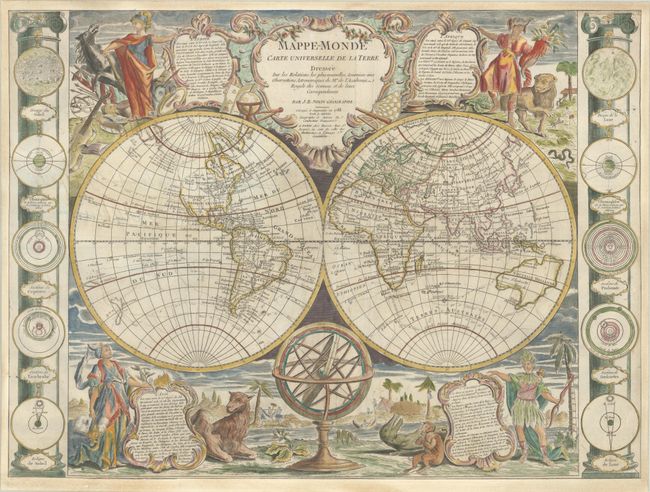
Lot 12
Subject: World
Nolin/Denis
Mappe-Monde Carte Universelle de la Terre Dressee sur les Relations les Plus Nouvelles, Soumises aux Observations Astronomiques de l'Academie Royale des Sciences..., 1788
Size: 25.5 x 18.9 inches (64.8 x 48 cm)
Estimate: $3,000 - $3,750
A Map with Popular Cartographic Myths and Unique Embellishments

Lot 26
Subject: North Pole
Pitt, Moses
A Map of the North-Pole and the Parts Adioning, 1680
Size: 23 x 18.1 inches (58.4 x 46 cm)
Estimate: $2,000 - $2,300
Beautiful English Map of the North Pole in Full Contemporary Color

Lot 27
Subject: Celestial, California
Cellarius/Schenk & Valck
Typus Aspectuum, Oppositionum et Coniunctionum etz in Planetis, 1708
Size: 20.2 x 17.1 inches (51.3 x 43.4 cm)
Estimate: $1,200 - $1,500
Cellarius' Chart Showing the Island of California

Lot 30
Subject: Solar System
Cellarius/Schenk & Valck
Planisphaerium Copernicanum sive Systema Universi Totius Creati ex Hypothesi Copernicana in Plano Exhibitum, 1708
Size: 20.6 x 17.3 inches (52.3 x 43.9 cm)
Estimate: $1,200 - $1,500
One of the Most Sought-after Charts from this Famous Work
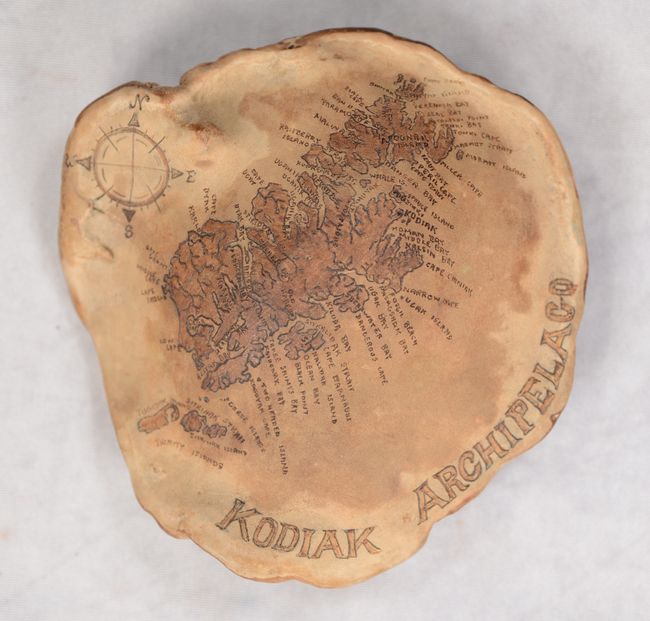
Lot 36
Subject: Cartographic Miscellany; Kodiak, Alaska
[Map on Dried Mushroom] Kodiak Archipelago, 1987
Size: 5.3 x 5.3 inches (13.5 x 13.5 cm)
Estimate: $150 - $180
Stunning One-of-a-Kind Map of Kodiak Engraved on a Dried Mushroom Cap

Lot 40
Subject: Cartographic Miscellany, Utopia
Homann, Johann Baptist
Accurata Utopiae Tabula das ist der Neu Entdeckten Schalck Welt, oder des so offt Benanten, und doch nie Erkanten Schlarraffenlandes..., 1710
Size: 21.5 x 18.8 inches (54.6 x 47.8 cm)
Estimate: $800 - $1,000
A Humorous Map of Utopia
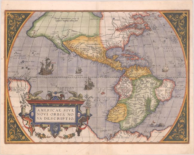
Lot 43
Subject: Western Hemisphere - America
Ortelius, Abraham
Americae sive Novi Orbis, Nova Descriptio, 1584
Size: 19.6 x 14.1 inches (49.8 x 35.8 cm)
Estimate: $4,750 - $6,000
Ortelius' Influential Map of the New World - Second Plate
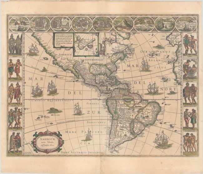
Lot 45
Subject: Western Hemisphere - America
Blaeu, Willem
Americae Nova Tabula, 1638
Size: 21.9 x 16.3 inches (55.6 x 41.4 cm)
Estimate: $4,000 - $4,750
Blaeu's Stunning Carte-a-Figures Map of the Americas in Full Contemporary Color

Lot 59
Subject: North America
Sayer, Robert
[On 2 Joined Sheets] A New Map of North America, with the West India Islands. Divided According to the Preliminary Articles of Peace, Signed at Versailles, 20, Jan. 1783..., 1786
Size: 46.3 x 20.2 inches (117.6 x 51.3 cm)
Estimate: $3,500 - $4,250
Important Large Map of North America Featuring the Nascent United States
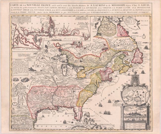
Lot 86
Subject: Colonial Eastern United States & Canada
Fer, Nicolas de
Carte de la Nouvelle France, ou se Voit le Cours des Grandes Rivieres de S. Laurens & de Mississipi Aujour d'hui S. Louis, aux Environs des-quelles se Trouvent les Etats, Pais, Nations, Peuples, &c. de la Floride, de la Louisiane, de la Virginie..., 1720
Size: 21.9 x 19.8 inches (55.6 x 50.3 cm)
Estimate: $2,750 - $3,500
Striking Map of French Colonial Possessions
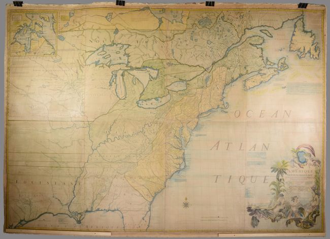
Lot 89
Subject: Colonial Eastern United States & Canada
Mitchell/Le Rouge
Amerique Septentrionale avec les Routes, Distances en Miles, Villages et Etablissements Francois et Anglois par le Docteur Mitchel, 1777
Size: 75 x 52.4 inches (190.5 x 133.1 cm)
Estimate: $9,500 - $12,000
Third French Edition of Mitchell's Monumental Map
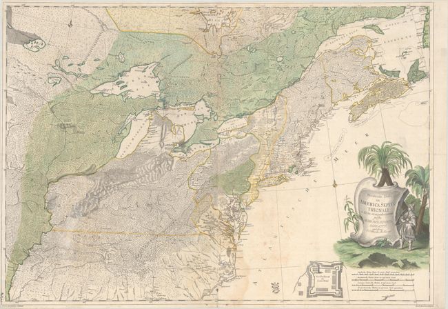
Lot 95
Subject: Colonial Northeastern United States & Canada
Rhode, Johann Cristoph
Theatrum Belli in America Septentrionali II. Foiliis Comprehensum..., 1755
Size: 31.5 x 22 inches (80 x 55.9 cm)
Estimate: $8,000 - $9,500
Scarce German Map Illustrating the French & Indian War
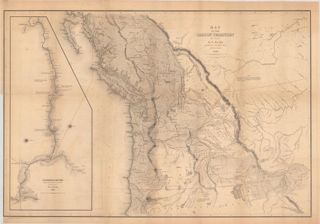
Lot 103
Subject: Northwestern United States & Canada
Wilkes, Charles
Map of the Oregon Territory by the U.S. Ex. Ex., 1841
Size: 34.1 x 22.9 inches (86.6 x 58.2 cm)
Estimate: $1,400 - $1,700
One of the Most Detailed and Important 19th-Century Maps of the American Northwest
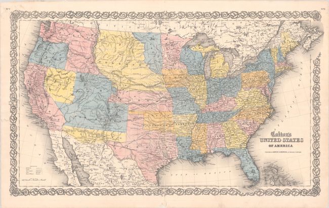
Lot 108
Subject: United States
Johnson & Browning
Colton's United States of America, 1859
Size: 26.5 x 15.7 inches (67.3 x 39.9 cm)
Estimate: $750 - $900
Scarce Map Featuring Colona
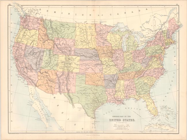
Lot 112
Subject: United States, Pembina
Bartholomew, John
General Map of the United States, 1875
Size: 22.3 x 16.6 inches (56.6 x 42.2 cm)
Estimate: $275 - $350
Scarce Map Depicting the Territory of Pembina

Lot 130
Subject: Eastern United States
Faden, William
The United States of North America: with the British Territories, and Those of Spain, According to the Treaty, of 1784, 1796
Size: 25 x 20.9 inches (63.5 x 53.1 cm)
Estimate: $4,000 - $4,750
Features the State of Franklin

Lot 139
Subject: Colonial New England & Mid-Atlantic United States
Blaeu, (Family)
Nova Belgica et Anglia Nova, 1643
Size: 19.9 x 15.3 inches (50.5 x 38.9 cm)
Estimate: $1,900 - $2,200
Important Map of Colonial New England and the Mid-Atlantic in Full Contemporary Color

Lot 140
Subject: Colonial New England & Mid-Atlantic United States
Visscher, Nicolas
Novi Belgii Novaeque Angliae nec non Partis Virginiae Tabula Multis in Locis Emendata, 1683
Size: 21.8 x 18.3 inches (55.4 x 46.5 cm)
Estimate: $3,250 - $4,000
Visscher's Influential Map with Early View of New York City

Lot 143
Subject: Colonial New England United States
Bowles, Carrington
Bowles's New Pocket Map of the Most Inhabited Part of New England; Comprehending the Provinces of Massachusets Bay and New Hampshire; with the Colonies of Connecticut & Rhode Island..., 1776
Size: 20.8 x 25.4 inches (52.8 x 64.5 cm)
Estimate: $3,750 - $4,500
Reduced-Size Edition of Jefferys/Mead Map with Revolutionary War Updates

Lot 149
Subject: Mid-Atlantic United States, Civil War
Bachmann, John
Panorama of the Seat of War. Birds Eye View of Virginia, Maryland Delaware and the District of Columbia, 1864
Size: 28.3 x 18 inches (71.9 x 45.7 cm)
Estimate: $1,200 - $1,500
Bachmann's Dramatic View of the Mid-Atlantic Region

Lot 153
Subject: Colonial Southeastern United States
Blaeu, Willem
Virginiae Partis Australis, et Floridae Partis Orientalis, Interjacentiumq Regionum Nova Descriptio, 1642
Size: 20 x 15.3 inches (50.8 x 38.9 cm)
Estimate: $1,000 - $1,300
Blaeu's Decorative Map of the Southeast in Full Contemporary Color

Lot 154
Subject: Colonial Southeastern United States
Keulen, Johannes van
Pas Kaart van de Kust van Carolina Tusschen C de Canaveral en C Henry, 1702
Size: 23 x 20.3 inches (58.4 x 51.6 cm)
Estimate: $2,000 - $2,400
Scarce Dutch Chart of the Carolinas
Lot 156
Subject: Southeastern United States
Bartram, William
Travels Through North & South Carolina, Georgia, East & West Florida, the Cherokee Country, the Extensive Territories of the Muscogulges, or Creek Confederacy, and the Country of the Chactaws..., 1791
Size: 5.9 x 9.8 inches (15 x 24.9 cm)
Estimate: $8,000 - $9,500
Complete First Edition of Bartram's Work on the American Southeast
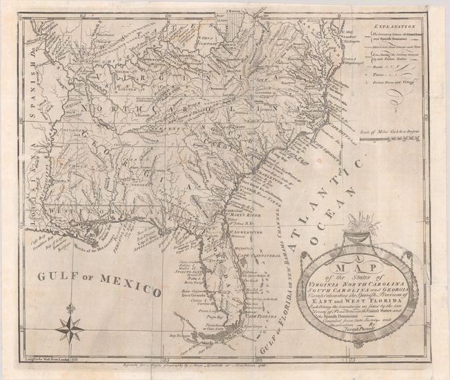
Lot 161
Subject: Southern United States, Franklin
Purcell, Joseph
A Map of the States of Virginia North Carolina South Carolina and Georgia Comprehending the Spanish Provinces of East and West Florida Exhibiting the Boundaries as Fixed by the Late Treaty of Peace Between the United States and the Spanish Dominions..., 1788
Size: 14.6 x 12.6 inches (37.1 x 32 cm)
Estimate: $1,000 - $1,300
Rare First State of Purcell's Map Locating the Proposed State of Franklin

Lot 164
Subject: Southern United States, Civil War
Wyld, James
Map of the Southern States of North America with the Forts, Harbours & Military Positions, 1861
Size: 40.9 x 26.8 inches (103.9 x 68.1 cm)
Estimate: $1,600 - $1,900
Scarce Civil War Map for a British Audience
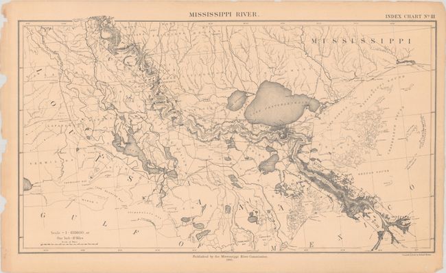
Lot 168
Subject: Mississippi River
Preliminary Map of the Lower Mississippi River from the Mouth of the Ohio River to the Head of the Passes in Thirty Two Sheets, 1881-85
Size: 23.8 x 14.8 inches (60.5 x 37.6 cm)
Estimate: $1,600 - $1,900
A Remarkable Production by the Newly Established Mississippi River Commission

Lot 169
Subject: Colonial Central United States, Mississippi River
Ross, John (Lt.)
Course of the River Mississipi, from the Balise to Fort Chartres; Taken on an Expedition to the Illinois, in the Latter End of the Year 1763..., 1775
Size: 13.6 x 44.2 inches (34.5 x 112.3 cm)
Estimate: $2,750 - $3,500
First English Map of the Lower Mississippi River
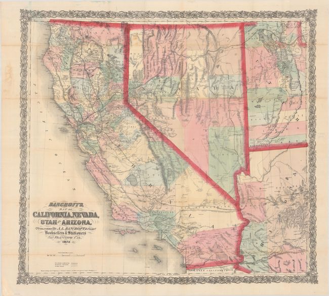
Lot 189
Subject: Southwestern United States
Bancroft, A.L. & Company
Bancroft's, Map of California, Nevada, Utah and Arizona, 1873
Size: 32.8 x 30.2 inches (83.3 x 76.7 cm)
Estimate: $1,100 - $1,400
From the Greatest Map Publisher of the Pacific Coast

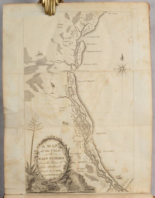
Lot 229
Subject: Amelia Island, Florida
Jefferys, Thomas
A Chart of the Entrance into St. Mary's River Taken by Captn. W. Fuller in November 1769 [on sheet with] Plan of Amelia Island in East Florida [and] A Chart of the Mouth of Nassau River... , 1770
Size: 24.1 x 20 inches (61.2 x 50.8 cm)
Estimate: $2,400 - $3,000
Important Charts Detailing Amelia Island and Surrounding Rivers
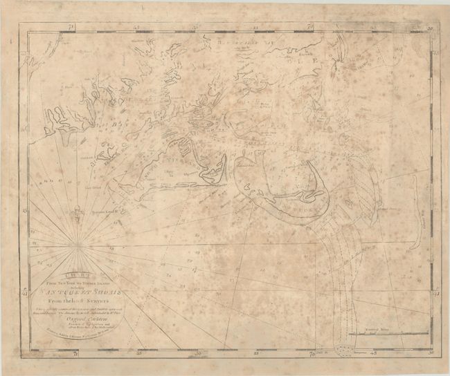
Lot 249
Subject: Southern Massachusetts, Martha's Vineyard & Nantucket Island
Norman, John
Chart from New York to Timber Island Including Nantucket Shoals from the Latest Surveys..., 1791
Size: 20.3 x 16.3 inches (51.6 x 41.4 cm)
Estimate: $2,750 - $3,500
Title Sheet of John Norman's Rare Chart of the New England Coastline, Featuring Martha's Vineyard and Nantucket Island
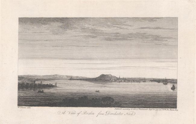
Lot 254
Subject: Boston, Massachusetts
Des Barres, Joseph Frederick Wallet
[On 2 Sheets - 6 Views of Boston], 1775
Size: 24.9 x 33.4 inches (63.2 x 84.8 cm)
Estimate: $2,750 - $3,500
Rare Set of Revolutionary War Period Views of Boston

Lot 264
Subject: New York City, New York
Dripps, Matthew
Map of New York and Vicinity, 1863
Size: 19.1 x 25.1 inches (48.5 x 63.8 cm)
Estimate: $750 - $900
Rare Dripps's Pocket Map of Manhattan Featuring Central Park Still Under Construction

Lot 296
Subject: Virginia, Native Americans
Bry, Theodore de
[Grands Voyages, Part I] Admiranda Narratio Fida Tamen, de Commodis et Incolarum Ritibus Virginiae, Nuper Admodum ab Anglis..., 1608
Size: 9.1 x 13.7 inches (23.1 x 34.8 cm)
Estimate: $2,300 - $2,750
Set of De Bry's Native Virginians & Picts from Part I of Grands Voyages
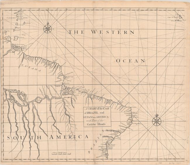
Lot 350
Subject: Eastern South America
Senex, John
[Lot of 2] A Chart of the Coast of Brazil and Guiana, in America: with Part of the Caribbe Islands [and] The East Coast of South America from Todos Sanctos to Sinifundi, 1728
Size: 23.5 x 19.6 inches (59.7 x 49.8 cm)
Estimate: $800 - $950
Rare Charts with Excellent Detail of Amazon River and Rio de la Plata

Lot 373
Subject: Europe
Jode, Gerard de
Nova Totius Europae Tabula ex Magnis Gerardi de Iudaeis P. Desumpta..., 1593
Size: 17.4 x 12.9 inches (44.2 x 32.8 cm)
Estimate: $6,000 - $7,500
De Jode's Very Rare Map of Europe

Lot 374
Subject: Europe
Blaeu, Willem
Europa Recens Descripta, 1663
Size: 21.7 x 16.1 inches (55.1 x 40.9 cm)
Estimate: $2,300 - $2,750
Blaeu's Carte-a-Figures Map of Europe in Full Contemporary Color
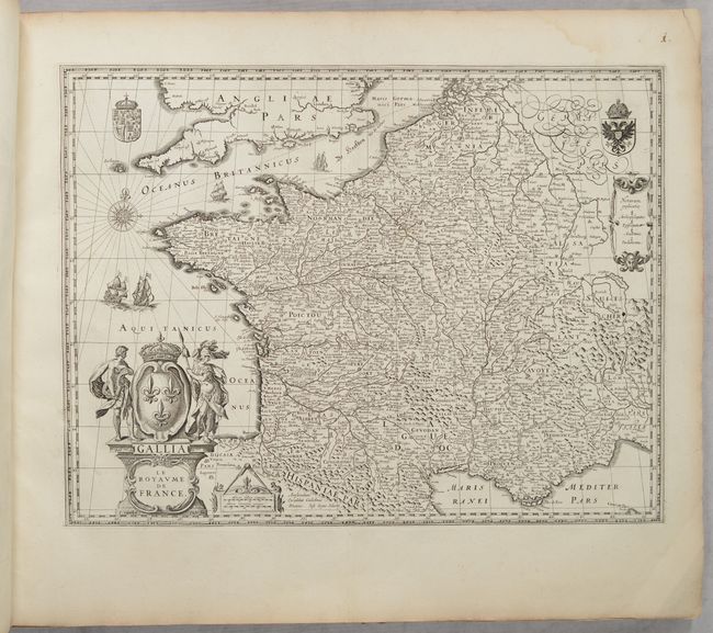
Lot 452
Subject: France, Atlases
Blaeu, (Family)
[Volume 2, Part 1] Novus Atlas, das ist Welt-beschreibung mit Schoenen Newen Ausfuehrlichen Land-Taffeln..., 1647
Size: 24 x 20 inches (61 x 50.8 cm)
Estimate: $3,500 - $4,250
Superb Atlas of France with 48 Maps

Lot 548
Subject: Russia, Eastern Europe & Central Asia
Ortelius, Abraham
Russiae, Moscoviae et Tartariae Descriptio. Auctore Antonio Ienkensono Anglo..., 1579
Size: 17.4 x 13.8 inches (44.2 x 35.1 cm)
Estimate: $1,200 - $1,500
Ortelius' Map of Russia with a Vignette of Ivan the Terrible in Full Contemporary Color

Lot 550
Subject: Russia in Europe
Blaeu, Willem
Tabula Russiae ex Autographo, quod Delineandum Curavit Foedor Filius Tzaris Boris Desumta ... M.DC.XIIII, 1650
Size: 21.6 x 16.8 inches (54.9 x 42.7 cm)
Estimate: $1,400 - $1,700
Blaeu's Decorative Map of Russia
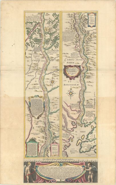
Lot 554
Subject: Dnieper River, Ukraine
Blaeu, (Family)
[Campus Inter Bohum et Borystenem] Lectori S. Hunc Borysthenis Tractum ut ad Nostrum Geographiae Tabulam…, 1634
Size: 12.8 x 29.6 inches (32.5 x 75.2 cm)
Estimate: $1,400 - $1,700
Blaeu's Strip-Map of the Dnieper River

Lot 590
Subject: Pisa, Italy
Wit, Frederick de
Pisa, 1696
Size: 16.3 x 13.3 inches (41.4 x 33.8 cm)
Estimate: $1,600 - $1,900
Scarce Bird's-Eye Plan of Pisa

Lot 623
Subject: Arabian Peninsula
U.S. Department of Interior
Arabian Peninsula, 1958
Size: 52.5 x 45 inches (133.4 x 114.3 cm)
Estimate: $2,000 - $2,300
Very Rare Early Issue of Foundational Geological Map of the Arabian Peninsula

Lot 655
Subject: China, Korea & Japan
Thevenot, Melchisedech
Imperii Sinarum Nova Descriptio, 1666
Size: 25 x 18 inches (63.5 x 45.7 cm)
Estimate: $1,600 - $1,900
Rare Map of China Based on Blaeu
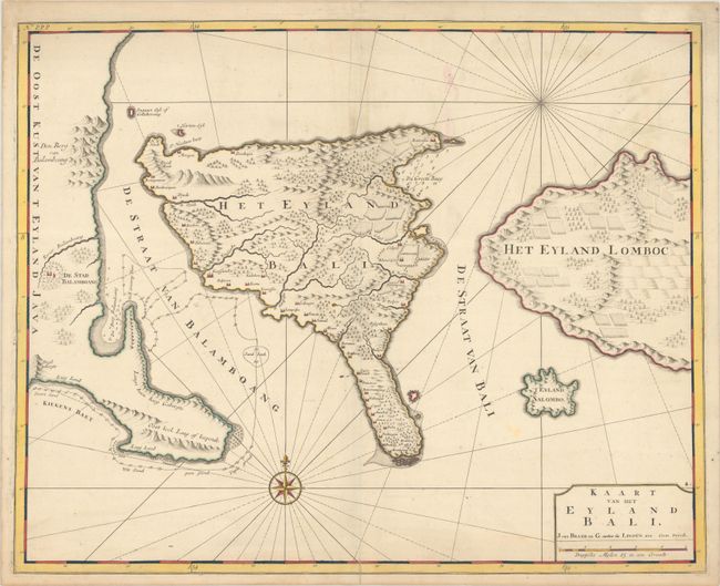
Lot 670
Subject: Bali, Indonesia
Valentyn, Francois
Kaart van het Eyland Bali, 1726
Size: 22.1 x 17.6 inches (56.1 x 44.7 cm)
Estimate: $1,100 - $1,400
Striking Early Map of Bali

Lot 678
Subject: Africa
Blaeu, Willem
Africae Nova Descriptio, 1634
Size: 22.1 x 16.3 inches (56.1 x 41.4 cm)
Estimate: $2,750 - $3,500
Blaeu's Carte-a-Figures Map of Africa
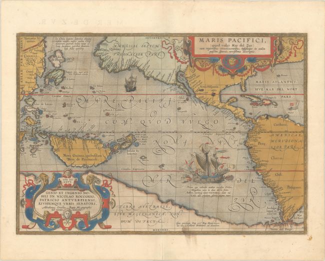
Lot 704
Subject: Pacific Ocean, Western Hemisphere
Ortelius, Abraham
Maris Pacifici, (quod Vulgo Mar del Zur) cum Regionibus Circumiacentibus, Insulisque, in Eodem Passim Sparsis, Novissima Descriptio, 1589
Size: 19.6 x 13.6 inches (49.8 x 34.5 cm)
Estimate: $7,500 - $9,000
The First Printed Map Devoted to the Pacific in Full Contemporary Color
Lot 748
Subject: Atlases
Blaeu, (Family)
Toonneel des Aerdrycx, oft Nieuwe Atlas ... Tweede Deel, 1642
Size: 13.5 x 20 inches (34.3 x 50.8 cm)
Estimate: $12,000 - $15,000
Second Volume of Blaeu's Atlas Featuring Maps of the Americas and Asia
Lot 749
Subject: Atlases
Lattre, Jean
Atlas Moderne ou Collection de Cartes sur Toutes les Parties du Globe Terrestre par Plusieurs Auteurs, 1762
Size: 12 x 15.3 inches (30.5 x 38.9 cm)
Estimate: $2,000 - $2,300
Complete Atlas with 35 Maps in Contemporary Color
Lot 763
Subject: Exploration & Surveys, Pacific Railroad
U.S. War Department
[3 Volumes] Report of the Secretary of War Communicating the Several Pacific Railroad Explorations, 1855
Size: 6 x 9.3 inches (15.2 x 23.6 cm)
Estimate: $2,000 - $2,400
Scarce, Complete Octavo Edition of Pacific Railroad Reports
51 lots
Page 1 of 2