Subject: Eastern United States, Civil War
Period: 1865 (dated)
Publication:
Color: Hand Color
Size:
35.8 x 24.9 inches
90.9 x 63.2 cm
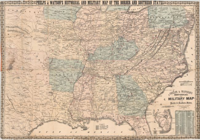
This important Civil War map focuses on the Confederate states including Texas, and the bordering states from Pennsylvania west to Nebraska. There is good detail throughout, including cities and towns, railroads, forts, and distances from place to place along the railroads. It presents the war's battles marked throughout with red colored dots. There are population statistics for each state and in the southern states slave populations are noted as well. The railroad network is well delineated but the lines are not named. In Florida the map ends in the vicinity of Bayport and Mellon with an inset on the same scale completing the state to Key West and Dry Tortugas. At lower right is an extensive list of "Battles of the War" which is continued in a small table in the Gulf of Mexico. The last battle listed was "Battles from the Rapidan to Spotsylvania Courthouse, Va" from May 4 to 12, 1864. Surrounded by decorative border with corner graphic elements. Map is attached to the rear cover (front cover is missing).
References:
Condition: B
Issued folding with numerous fold separations that have been closed on verso with archival tape with some small image loss at a couple of fold junctions. There is minor foxing, a small dampstain below the title, and some staining at left where the map was glued to the inside of the rear cover. Trimmed to the decorative border as issued. Front cover is missing.