Showing Featured Lots(remove filter)
Filtered by Category:United States(Show All Categories)
Showing results for:Auction 194
Catalog Archive
13 lots
Auction 194, Lot 108
Subject: Eastern United States & Canada
Ruscelli, Girolamo
Tierra Nueva, 1574
Size: 9.8 x 7.1 inches (24.9 x 18 cm)
Estimate: $1,200 - $1,500
Ruscelli's Map of the East Coast
Sold for: $750
Closed on 9/13/2023
Auction 194, Lot 109
Subject: Colonial Northeastern United States & Canada
Robert de Vaugondy, Didier
Carte des Pays Connus sous le Nom de Canada, dans Laquelle sont Distinguees les Possessions Francoises, & Angl?..., 1755
Size: 26.4 x 18.9 inches (67.1 x 48 cm)
Estimate: $2,000 - $2,400
A Separately Issued, French Political Propaganda Map at the Outset of the French & Indian War
Sold for: $1,500
Closed on 9/13/2023
Auction 194, Lot 124
Subject: United States
Phelps & Watson
Phelps' New National Map of the United States, 1859
Size: 35.8 x 38 inches (90.9 x 96.5 cm)
Estimate: $2,400 - $3,000
Attractive Wall Map Issued at the Onset of the Civil War
Sold for: $1,800
Closed on 9/13/2023
Auction 194, Lot 142
Subject: Colonial Eastern United States
Delisle, Guillaume
Carte de la Louisiane et du Cours du Mississipi Dressee sur un Grand Nombre de Memoires Entr'autres sur ceux de Mr. le Maire, 1718
Size: 25.6 x 19.2 inches (65 x 48.8 cm)
Estimate: $6,000 - $7,500
A Foundation Map for the Mississippi Valley and the First Appearance of Texas on a Printed Map - First Issue
Sold for: $8,000
Closed on 9/13/2023
Auction 194, Lot 149
Subject: Eastern United States, Texas
Lay, Amos
Lay's Map of the United States. Compiled From the Latest and Best Authorities and Actual Surveys, 1827
Size: 60 x 51 inches (152.4 x 129.5 cm)
Estimate: $2,750 - $3,500
First Edition of Lay's Mammoth Map of the Young United States - Early Naming of Austin's Settlement
Sold for: $2,400
Closed on 9/13/2023
Auction 194, Lot 155
Subject: Colonial New England & Mid-Atlantic United States
Blaeu, Willem
Nova Belgica et Anglia Nova, 1641
Size: 19.9 x 15.2 inches (50.5 x 38.6 cm)
Estimate: $2,000 - $2,300
Important Map of Colonial New England and the Mid-Atlantic
Sold for: $1,500
Closed on 9/13/2023
Auction 194, Lot 156
Subject: Colonial New England & Mid-Atlantic United States
Jansson, Jan
Nova Anglia Novum Belgium et Virginia, 1645
Size: 19.9 x 15.3 inches (50.5 x 38.9 cm)
Estimate: $1,200 - $1,500
Jansson's Influential Map of the East Coast
Sold for: $900
Closed on 9/13/2023
Auction 194, Lot 161
Subject: Colonial New England & Mid-Atlantic United States, Revolutionary War
Brion de la Tour, Louis
Carte du Theatre de la Guerre Entre les Anglais et les Americains: Dressee d'Apres les Cartes Anglaises les Plus Modernes, 1778
Size: 20.4 x 29.9 inches (51.8 x 75.9 cm)
Estimate: $3,000 - $3,750
Important Map Depicting Tipping Point of Revolutionary War
Unsold
Closed on 9/13/2023
Auction 194, Lot 167
Subject: Colonial Mid-Atlantic United States
Browne/Senex
A New Map of Virginia Mary-Land and the Improved Parts of Pennsylvania & New Jersey..., 1719
Size: 21.8 x 19.1 inches (55.4 x 48.5 cm)
Estimate: $3,250 - $4,000
Map of Chesapeake Bay Based on Landmark Herrman Map
Unsold
Closed on 9/13/2023
Auction 194, Lot 277
Subject: Lake Champlain, Colonial New York, Revolutionary War
Faden, William
The Attack and Defeat of the American Fleet Under Benedict Arnold, by the Kings Fleet Commanded by Sir Guy Carleton, Upon Lake Champlain, the 11th of October, 1776, 1776
Size: 16.4 x 10.4 inches (41.7 x 26.4 cm)
Estimate: $6,000 - $7,500
One of the Rarest Revolutionary Battle Plans
Sold for: $6,000
Closed on 9/13/2023
Auction 194, Lot 293
Subject: Pennsylvania
Barnes, R. L.
Map of Pennsylvania, Constructed from the County Surveys Authorized by the State; and Other Original Documents, Revised and Improved..., 1850
Size: 74.6 x 50.4 inches (189.5 x 128 cm)
Estimate: $3,000 - $3,750
Melish's Epic Map of the State - Updated by William Morris
Unsold
Closed on 9/13/2023
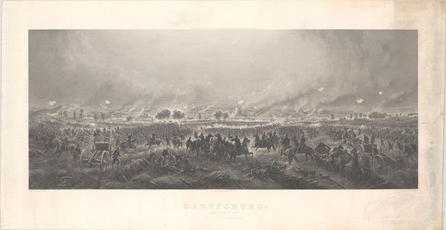
Auction 194, Lot 295
Subject: Gettysburg, Pennsylvania, Civil War
Bachelder, John B.
Gettysburg. Repulse of Longstreet's Assault, 1876
Size: 35 x 14.4 inches (88.9 x 36.6 cm)
Estimate: $1,600 - $1,900
Stunning View of Pickett's Charge
Unsold
Closed on 9/13/2023
Auction 194, Lot 305
Subject: Virginia & West Virginia
Bucholtz, Ludwig von
A Map of the State of Virginia Reduced from the Nine Sheet Map of the State, in Conformity to Law: by Herman Boye, 1859
Size: 47.5 x 29.8 inches (120.7 x 75.7 cm)
Estimate: $14,000 - $17,000
Bucholtz Edition of Herman Boye's Four-Sheet Map of Virginia
Unsold
Closed on 9/13/2023
13 lots


