New Rail Road and County Map of Indian Territory… (1882) by George Cram & Company. (Image courtesy of Old World Auctions)
No Man’s Land: The Cartographic Evolution of the Oklahoma Panhandle
by Jon Dotson
The phrase “No Man’s Land” (NML) was used to describe the present-day Oklahoma Panhandle in the mid-1880s. At the time, it was neither part of a U.S. territory nor was it explicitly designated as Indian lands. This strip of land, measuring approximately 34 miles wide by 166 miles long, was simply unassigned land owned by the United States government, meaning that no one could legally settle the region. While the term NML was first applied in the late 19th century, ownership of this region had been in question as early as the 1830s and the area was “created” as a result of three different boundary events that occurred between 1836-50.
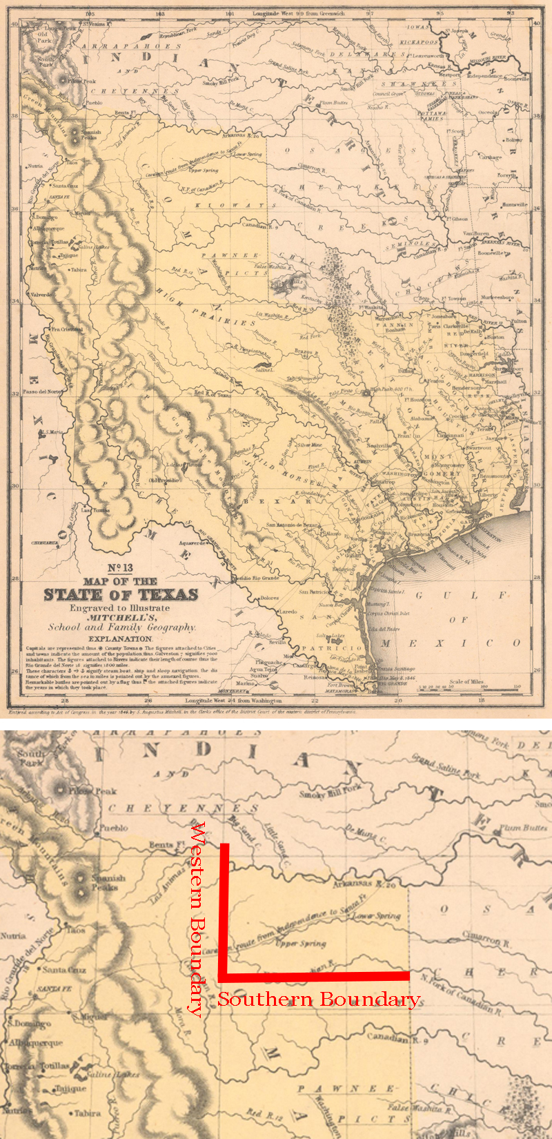
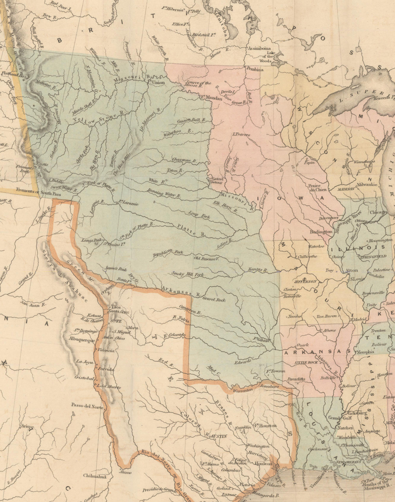
NML’s southern and western boundaries were created as a direct result of the Compromise of 1850. Texas, which became a U.S. state in late 1845, forfeited its claims to territory north of the 36° 30’ line and west of the 103rd meridian in return for the assumption of up to $10 million in Texas debt by the United States government. The U.S. required that Texas, a slave-holding state, use the 36° 30’ line as its northern boundary in order to comply with the Missouri Compromise (which stated that slavery was illegal north of this line). The Compromise of 1850 also established the large New Mexico Territory, whose eastern boundary met the new western border of Texas along the 103rd meridian.
No. 13 Map of the State of Texas (1846) by Samuel Augustus Mitchell with the new Compromise of 1850 boundaries that would form the western and southern boundaries of NML. (Images courtesy of Old World Auctions)
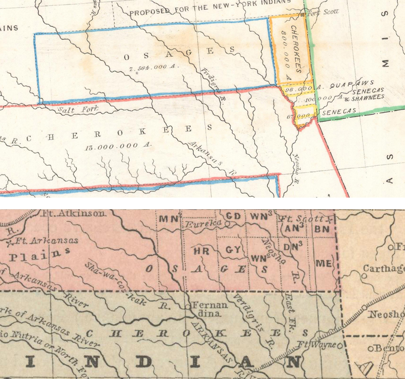
NML’s northern boundary was established by the Kansas-Nebraska Act in 1854. The act itself was highly significant for its repeal of the Missouri Compromise, meaning that individual territories could decide the slavery issue on their own regardless of where they fell on the map. The repeal also gave Congress more flexibility in establishing territorial boundaries, so instead of using the 36° 30’ line for Kansas’ southern border as Missouri had done, they set the boundary half a degree north along the 37th parallel. This was a practical choice by the government, as the 37th parallel had previously served as the boundary line between the Osage Nation in Kansas and the Cherokee Nation to its south (established in 1828 and 1833 respectively). Had Congress opted to continue the 36° 30’ line, the Cherokee Nation would have been split in two. Martin notes that “it is possible that in outlining the bounds of the new territory the line between these two tribes was adopted as least liable to arouse controversy.”
The northern boundary of NML at the 37th parallel was also the dividing line between Osage and Cherokee Lands. Had the 36° 30’ line been used, Cherokee Lands would have been split between the two territories. Top image: Map of the Indian Colonies West of Missouri and Arkansas (1853) by Seth Eastman; bottom image: Kansas, Nebraska, Minnesota, Indian Territory, Dacotah (1860) by Roswell Smith. (Images courtesy of Old World Auctions)
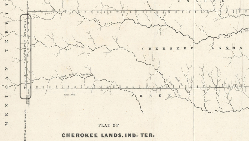
NML’s final and most complicated piece of the boundary puzzle, the eastern boundary, was established as a result of Isaac McKoy’s survey of newly apportioned Cherokee lands to its east. In 1836, the Treaty of Echota was signed by the United States and Cherokee Nation. The treaty stipulated that in return for ceding all lands east of the Mississippi River (mostly northern Georgia), the Cherokee Nation would receive an additional 7 million acres of land, named the Cherokee Outlet, adjacent to their existing reservation in present-day northeastern Oklahoma. While the treaty was never formally approved by the Cherokee National Council, the “removal process,” more commonly known as the Trail of Tears, began in 1838. McCoy’s survey, one of the earliest to depict present-day Oklahoma in any detail, presented the Cherokee Outlet’s western boundary at the 100th meridian, thus forming the eastern boundary of No Man’s Land.
From Plat of Cherokee Lands. Ind: Ter: Surveyed Under Instructions from Isaac McCoy (1837) showing the western border of the Cherokee Outlet at left, which served as the eastern boundary of No Man’s Land (which was Mexican Territory at the time. (Image courtesy of Old World Auctions)
McKoy’s survey includes an interesting twist with a notation along the 100th meridian indicating “Western Limits of the United States.” This refers to an important point in the language of the Treaty of Echota that stated “In addition to the seven millions of acres of land thus provided for and bounded, the United States further guaranty to the Cherokee nation a perpetual outlet west, and a free and unmolested use of all the country west of the western boundary of said seven millions of acres, as far west as the sovereignty of the United States.” With victory in the Mexican-American War in 1848 and Texas releasing its claims above the 36° 30’ line in 1850, this region officially transitioned from Mexican Territory to an unnamed part of the sovereignty of the United States. Was this land therefore a western extension of the Cherokee Nation?
Prior legislation suggests that this area was in fact part of Indian Territory. The Indian Removal Act of 1830, which was narrowly passed in the House by a 101-97 margin, provided "for an exchange of lands with the Indians residing in any of the states or territories, and for their removal east of the river Mississippi." It defined the new lands to be settled, or Indian Territory, “as the region belonging to the United States west of the Mississippi River but excluding the states of Missouri and Iowa as well as the Territory of Arkansas.” This established a huge Indian region extending to the northern Rocky Mountains, though the architects of the legislation likely never intended it to remain as large. Beginning in the 1850s, new western territories were added throughout the Plains region (Kansas, Nebraska, Minnesota, Colorado, Dakota, etc.) and continued to whittle down Indian Territory’s size from the north. Despite this territorial growth, cartographic evidence reinforced that NML was still considered Cherokee land up until the Civil War.
Indian Territory (in green and pink) per the Act of 1830 encompassed much of the original Missouri Territory. From United States of America (1845) by James Wyld. (Image courtesy of Old World Auctions)
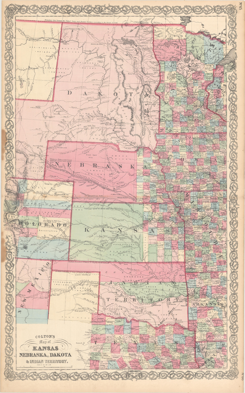
Only 34 years after the Removal Act, much of Indian Territory was consumed by new territories but NML remains. From Colton's Map of Kansas Nebraska, Dakota & Indian Territory (c. 1864). (Image courtesy of Old World Auctions)
The Civil War saw division amongst the Cherokee Nation membership. Some members continued their allegiance to the Union while others, under the direction of Stand Watie, joined the Confederacy. Having been exposed to white settlers during their time in the Southeast, many Cherokees adopted the practices of Southerners including farming and the use of slave labor. They were also geographically and economically aligned with the southern states. Perhaps most importantly, many Cherokees were alarmed by President Lincoln’s expansionist policies, including the signing of the Pacific Railroad and Homestead acts of 1862. Siding with the Confederacy appeared to be a way to protect both land and sovereignty. Watie became a prominent member of the Confederate military, having risen to the rank of Brigadier General (the highest ranking Indian in the war), and was responsible for successful campaigns in both Indian Territory and Arkansas. He was also the last general to surrender in the Civil War – nearly 2 months after Robert E. Lee’s surrender at Appomattox Courthouse.
Following the conclusion of the Civil War, the Cherokee Nation signed a new treaty with the United States in 1866. The treaty featured a particularly unfavorable clause for the Cherokees that would enable other Indian tribes to settle on the eastern side of Cherokee Outlet. The clause resulted not only in a loss of tribal lands in the immediate vicinity, but also the Cherokee’s access to lands west of the Outlet, i.e. No Man’s Land. The treaty read:
“The United States may settle friendly Indians in any part of the Cherokee country west of 96°… The Cherokee Nation to retain the right of possession of and jurisdiction over all of said country west of 96° of longitude until thus sold and occupied, after which their jurisdiction and right of possession to terminate forever.”
Just two years after this treaty was signed, the term “Public Lands” appeared in No Man’s Land on a map for the very first time. The map was issued in the Annual Report of the General Land Office, the government’s arm responsible for the sale and disposal of federal lands.
The first appearance of the term “Public Lands” on a map. From Map of the United States and Territories Showing the extent of Public Surveys (1868) by the GLO. (Image courtesy of the Library of Congress)
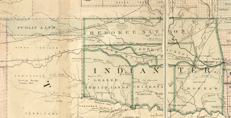
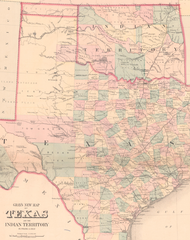
Commercial cartographers, including Frank Gray and the Colton firm, would follow this new designation of Public Lands over the coming years, with rapidly evolving configurations to its east as additional tribes settled in Indian Territory.
Gray's New Map of Texas and the Indian Territory (1875). (Image courtesy of Old World Auctions)
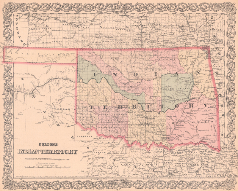
Colton’s Indian Territory (1876). (Image courtesy of Old World Auctions)
Over the next 15-20 years, NML would continue to be identified as “Public Lands” on maps, but with little to no cartographic detail. In reality, this region was an uninhabited grassland that was used primarily by the southern Plains Indians as hunting grounds until the Red River War (1874) pushed these nomadic tribes out of the region and into Indian Territory. Following their removal, NML was utilized by opportunistic Texas cattlemen who improvised free-range ranches. In some cases, these ranchers even made payments to lease the Public Lands from the Cherokee Nation, demonstrating the confusion over who actually owned the area.
Finally, in 1885, the U.S. Supreme Court ruled that this land was not part of the Cherokee Outlet, and the following year Interior Secretary Lucius Q.C. Lamar declared it in the public domain. As news of Lamar’s statement spread, more settlers arrived hoping to gain title by squatter’s rights. Shortly thereafter, local leaders attempted to gain legal status for the area under the name Cimarron Territory, and operated with an unsanctioned provisional government until 1889. Surprisingly, Cimarron Territory was actually approved by Congress (to be attached to Kansas), but the legislation was never signed by President Grover Cleveland.
Instead, in 1890 the Organic Act created both Oklahoma and Indian territories, with the unassigned Public Lands included as a part of Oklahoma Territory. As a result, No Man’s Land was renamed Beaver County with a land office at the county seat of Beaver City. Surveying work was completed over the next two years, and those who had squatted could submit their claims to the new land office for title. While No Man’s Land had dwindled to only 2,700 citizens when it became Beaver County (many had moved east to participate in Oklahoma’s first land run of 1889), its population had grown to over 13,000 at the time of statehood in 1907, at which point Beaver County was split into three separate counties (Cimarron, Texas and Beaver). Unfortunately, this region became the epicenter of the Dust Bowl in the 1930s, and population in the panhandle decreased by 30% from 1930 to 1940. Since that time, population has grown to approximately 28,000 by 1980 and has held relatively steady over the last 45 years. On a population density basis, the panhandle has just 5 people per square mile, less than the average for all states except Alaska. The fascinating and rather obscure history of No Man’s Land evolved from Mexican territory to Indian Territory, Public Lands, Cimarron Territory, and finally Oklahoma in a span of only 60 years. These changes are reflected on a number of maps published during the mid- to late-19th century that document the history of No Man's Land.
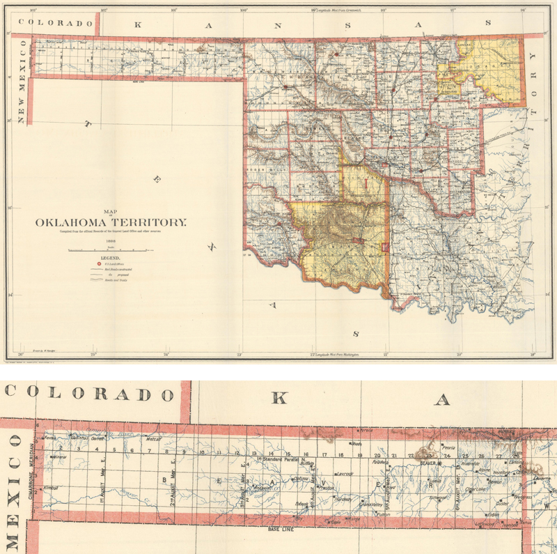
At top are the newly formed Oklahoma (west) and Indian (east) territories. At bottom, Public Lands in the panhandle was renamed Beaver County and fully surveyed into townships. From Map of Oklahoma Territory. Compiled from the Official Records of the General Land Office and Other Sources (1898) by the General Land Office. (Images courtesy of Old World Auctions)
Kappler, Charles J., “Treaty with the Cherokee, 1835.” Indian Affairs. Laws and Treaties. Volume II (Treaties), Government Printing Office, Washington DC, 1904.
Martin, George. “The Boundary Lines of Kansas.” Transactions of Kansas State Historical Society, Vol. 11 (1910).