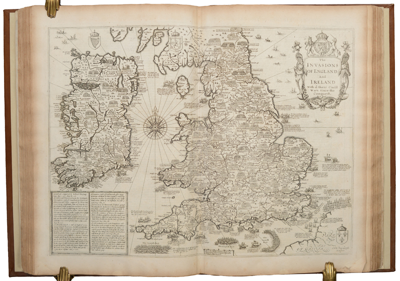
An example of the folio-sized edition of Speed’s historical military map of England, Wales and Ireland. (Image courtesy of Old World Auctions)
The Life and Works of John Speed
by Eliane Dotson
John Speed was born in Farndon, Cheshire in 1552. His father, also named John Speed, was a tailor and had gained the freedom of the Company of Merchant Taylors in London in 1556. John Speed the younger followed in his father’s footsteps, learning the trade and working as a tailor. The younger Speed married Susannah Draper around 1572, with whom he had 12 sons and 6 daughters. He must have been relatively successful in his career, as his children were educated at Oxford, and one of his sons, also named John Speed, became a doctor of some renown.
Speed gained freedom of the Company of Merchant Taylors via patrimony in 1580, and despite his achievements in the trade, his true passions were in history and genealogy. His interests drew him to the Society of Antiquaries, to which he became a member. The Society not only fostered his interests, but also introduced him to individuals who would play a pivotal role in his career and success, including William Camden, Robert Cotton, and William Smith. In 1595 he created a four-sheet wall map, “Canaan as it Was Possessed both in Abraham and Israels Dayes,” an example of which still exists in the National Library of Israel. Around this time, he caught the attention of Sir Fulke Greville, whose patronage enabled Speed to resign from the manual trade and pursue his interests in studying history. Speed paid respect to Greville within the text that accompanied his map of Warwickshire:
“…the right worthy Knight Sir Foulke Grivel (in whose person thineth all true virtue and high nobilitie) … whose merits to me-ward I doe acknowledge, in setting this hand free from the daily imployments of a manual trade, and giving it full libertie thus to expresse the inclination of my minde, himself being the Procurer of my present estate.”
Speed had great admiration for Queen Elizabeth I, writing that she “was for wisdom, virtue, piety and justice not only the mirror of her sex but a pattern for government to all the princes in Christendom.” With Sir Greville’s assistance, he presented the Queen with several maps in 1598, and was later rewarded with a sinecure appointment as a Waiter with the Customs Service and a room in the Custom-House. Speed focused his time learning of the antiquities and history of England, spending time in Robert Cotton’s library to study his collection of seals, coins and medals, learning about heraldry from William Smith, and refining his skills in cartography with William Camden.
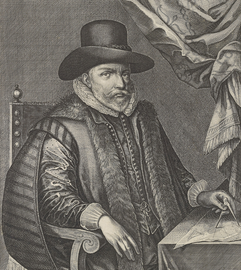
A portrait of John Speed engraved by Salomon Savery that was used as a frontispiece to the 1632 edition of A Prospect of the Most Famous Parts of the World and the 1632 edition of Historie of Great Britaine (Image courtesy of the Royal Collection Trust)
Speed endeavored to put his knowledge to use and began to work on the History of Great Britain, a large, comprehensive volume that was filled with information beginning in Roman times through to the early 17th century. It included numerous engravings of seals, coat of arms, coins, weapons, and dress, as well as tables of genealogy and statistics. He envisioned an atlas to accompany the History that would feature maps of England, Wales, Scotland, Ireland and their counties. He titled the atlas volume The Theatre of the Empire of Great Britaine, copying the term “theatre” from Abraham Ortelius’ Theatrum Orbis Terrarum. Speed partnered with John Sudbury and George Humble, the largest publishers in London, to supervise the publication of his work. Sudbury and Humble recommended Jodocus Hondius Sr. to engrave the maps. Hondius had spent nearly a decade residing in England, and his superior engraving skills and knowledge of the English language made him a good choice for the project. William Camden wrote a letter to Hondius on Speed’s behalf, encouraging him to engrave for Speed.
However, at the beginning of the 17th century, Hondius was residing in Amsterdam, which may have slowed the process of publishing The Theatre. Manuscript maps were sent to Amsterdam, where Hondius engraved them on copperplates and then sent printed proofs back to London. Corrections were noted on the proofs and then sent back to Amsterdam for Hondius to amend on the plates. The finished plates were finally sent to London in 1611, and William Hall and John Beale were hired to typeset the text for the work. The text was largely derived from Camden (undoubtedly with his permission due to their friendship), with the exception of the text on Norfolk, which came from Henry Spelman, and Huntingdonshire, which was likely from Robert Cotton.
The maps were dated between 1605-1611 and the main title page of The Theatre bears the publication date of 1611. However, the volume was not completed until 1612, and thus the title pages for the latter parts on Scotland and Ireland are dated 1612. There are no surviving records of the number of examples that were printed, but scholars estimate that between 500-1,000 copies were printed of the first edition. The price of the first edition is also unknown; however, the 1614 and 1627 editions were priced at £2 bound and £1.50 unbound. Hand-colored examples were also available by request, although it was uncommon for volumes to be colored due to the high cost, as it would likely have increased the price by 25-30%. Each of the maps included the full name and address of the publishers (e.g., “to be sold in Popes Head Alley by John Sudbury and George Humble”), which was unusual for atlas maps at the time and indicates that they were probably also made available for sale individually.
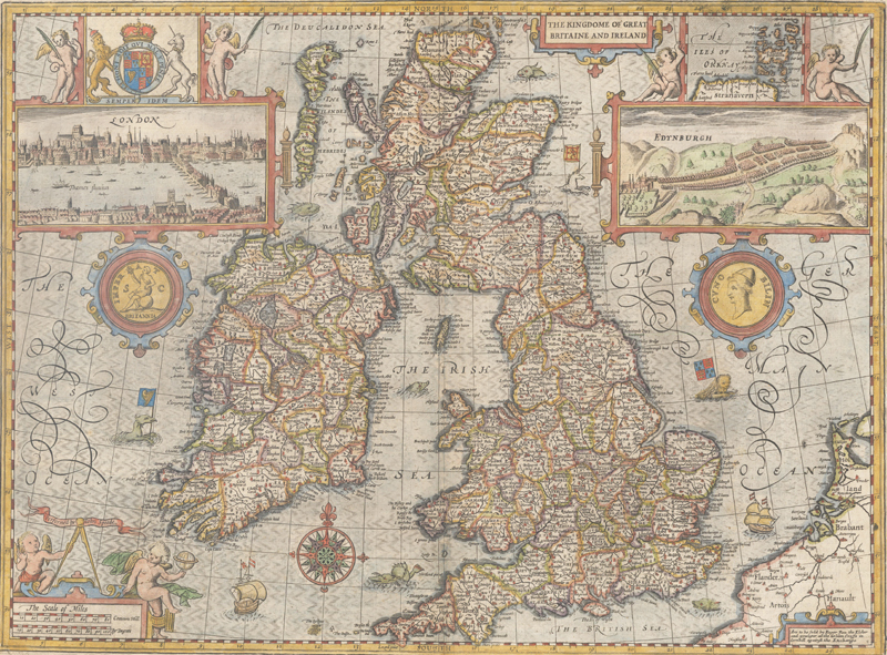
Speed’s map of the British Isles was engraved by Jodocus Hondius and includes inset views of London and Edinburgh. (Image courtesy of Old World Auctions)
The atlas was intended as a complement to the History of Great Britain, and as such, the maps were not created to assist in general navigation. Thus roads are not depicted on the maps, with the exception of the city plans that were featured in some of the insets. Each county map showed evidence of Speed’s interest in history, the antiquities, and genealogy, with decorative vignettes and notations on pre-historic and Roman remains, famous battle sites, and coats of arms of important families. Although Speed’s county maps were largely copied or adapted from maps by William Smith, Robert Cotton, Christopher Saxton, John Norden and others, he made several cartographic improvements over his contemporaries. For one, he more accurately mapped the administrative divisions of the counties, including lathes, hundreds, wapentakes, and cantreds. In addition, he added numerous town plans, many of which had not previously been mapped. As a result, The Theatre served as the first collection of printed plans within England and Wales. But perhaps his greatest achievement was amalgamating such a breadth of history and cartography into the History of Great Britain and The Theatre that served as an indispensable resource for his compatriots.
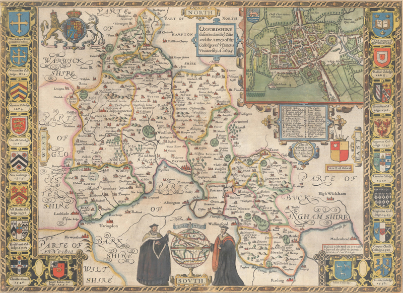
Speed’s stunning map of Oxfordshire includes a bird’s-eye plan of the city, the coats of arms of Oxford University and its colleges, and a pair of scholars studying a terrestrial globe. (Image courtesy of Old World Auctions)
Following the success of The Theatre, in 1627 John Speed and George Humble (John Sudbury had retired around 1618), published a world atlas, A Prospect of the Most Famous Parts of the World, with 22 maps, nearly all of which were attributed to John Speed. The maps were again engraved in Amsterdam, this time by Abraham Goos, Evert Symontsz Hamersveldt, and Dirck Gryp. These maps were also based on contemporary sources by (mostly Dutch) mapmakers such as Willem Blaeu, Pieter van den Keere, Claes Janz Visscher, and Jodocus Hondius. Three of the maps do not bear Speed’s name: the XVII Provinces (which may have been accidental), the world, and Bermuda. The world map bears similarities both to Jodocus Hondius Jr.’s map published in 1617, as well as Thomas Grent’s map from 1625. As Grent, a fellow Englishman, had obtained copyright protection for his map, it is possible that Speed’s name was omitted from the world map purposefully. Similarly, the Bermuda map was based on a manuscript map by Richard Norwood that had been registered in 1622, and therefore Speed’s edition was not attributed to himself, yet also did not credit Norwood. Speed seems to excuse his practice of copying the material of others within his address to the readers in The Theatre: “…it may be objected that I have put my sickle into other men’s corne, and have laid my Building upon other men’s Foundations (as indeed who can doe otherwise).”
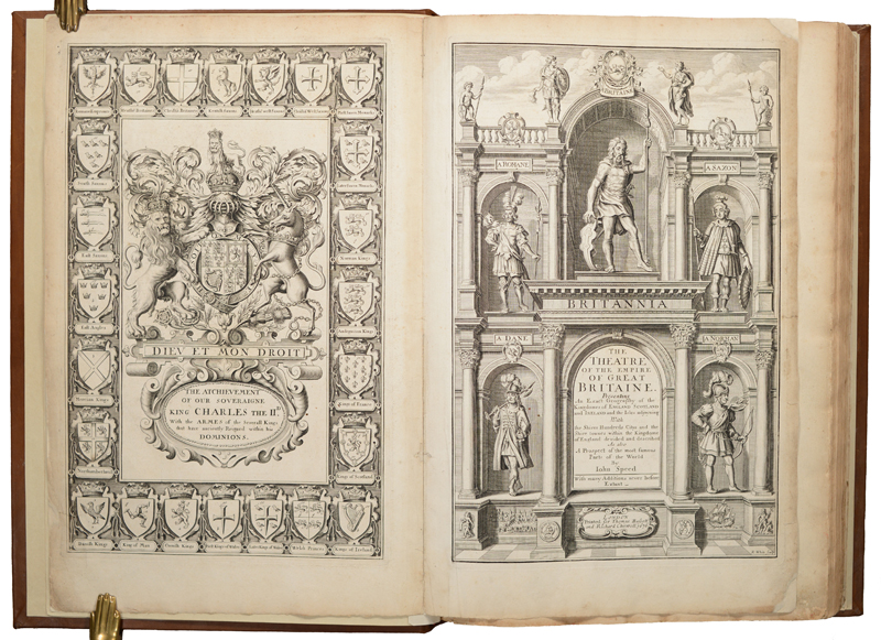
The title page and frontispiece to the 1676 edition of The Theatre include the royal coat of arms of Charles II and images of the conquerors of Great Britain: Roman, Saxon, Danish, and Norman. (Image courtesy of Old World Auctions)
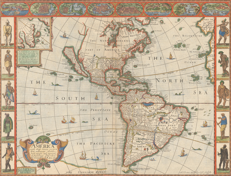
One of the most important maps in the atlas was Speed’s map of the Americas, which included information combined from several sources. While the carte-a-figures border was closely copied from Dutch sources, there were numerous updates based on British sources. In North America, the British colonies, the Southwest, and the West Coast all feature new information, some of which was derived from Henry Briggs’ map of the continent that had been published in Samuel Purchas’ Purchas His Pilgrimes in 1625. One of the most intriguing aspects of the map, which originated from Spanish sources and also appeared on Briggs’ map, was California depicted as an island. The popularity of Speed’s Prospect helped propagate the cartographic myth for more than a century.
Speed’s popular carte-a-figures map of the Americas depicts California as an island and is surrounded by a border containing vignettes of major cities and costumed native figures. (Image courtesy of Old World Auctions)
It is not known how much involvement John Speed had in the creation of the Prospect. The maps are dated 1626, when Speed was 74 years old and already suffering problems with his vision. In addition, the Prospect, although it was typically bound together with The Theatre of the Empire of Great Britaine, differed greatly from the work. While The Theatre was detailed, thorough, and historical, the Prospect was perfunctory. The maps that were included were largely determined based on the availability of Dutch maps that could be copied, rather than offering a comprehensive world atlas. As a result, there are several maps that are notably missing, such as a map focusing on the British colonies in North America, and a map of the Holy Land, the latter of which Speed had readily available (another clue that Speed may not have been closely involved with the Prospect). In addition, the text that accompanied the maps was minimal, and appears to have been taken from Peter Heylyn’s Microcosmus from 1625.
It is possible that the Prospect was rushed to publication to fill a void in the market. Abraham Ortelius’ popular Theatrum Orbis Terrarum had ceased publication in 1612, and the Mercator-Hondius atlas, which first appeared on the market in 1595, was now out of date and losing its relevancy. And due to George Humble’s work with various Dutch engravers, he likely suspected that the major Dutch publishing firms, such as Hondius-Jansson or Willem Blaeu, were on the verge of publishing their own atlases with newly engraved plates (which would appear on the market beginning in 1630). And by offering the Prospect in English, Humble was able to capitalize on a nation that had been largely ignored by Dutch publishers, who typically only offered one English edition, or none at all.
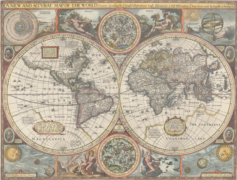
Speed’s highly-desirable, double-hemisphere world map also depicts California as an island, and is surrounded by celestial hemispheres, figural allegorical representations of Water, Earth, Air and Fire, plus portraits of explorers Ferdinand Magellan, Oliver vander Noort, Thomas Cavendish and Sir Francis Drake. (Image courtesy of Old World Auctions)
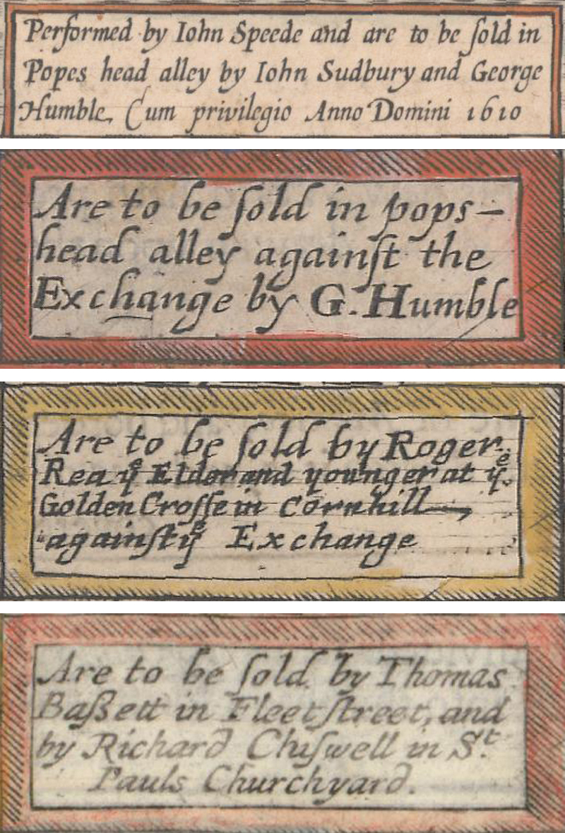
The rights to the folio editions of the Theatre and the Prospect were owned by John Sudbury and George Humble, not John Speed. After Sudbury retired circa 1618, the plates became the full property of George Humble, and were passed to his son, William, after George’s death in 1640. William Humble published several editions and then sold the rights to the plates and atlases to William Garrett in 1659, who never published them himself, but rather sold them to Roger Rea the Elder and Younger soon thereafter. The Reas only published one edition around 1665, and then circa 1675 the plates passed to Thomas Bassett and Richard Chiswell. As the maps passed to each new owner, the imprints on each title page and map were generally re-engraved to reflect the new publisher, with the exception of William Humble, who only included his name on the secondary title pages, and Garrett, who never published the maps or atlases.
Examples of the imprints of the different publishers. (Images courtesy of Old World Auctions)
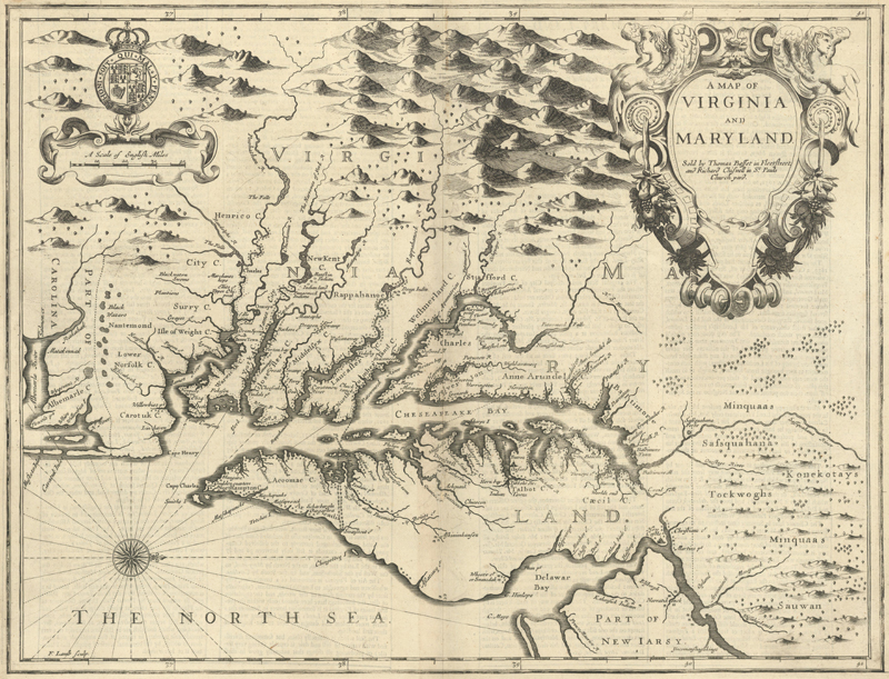
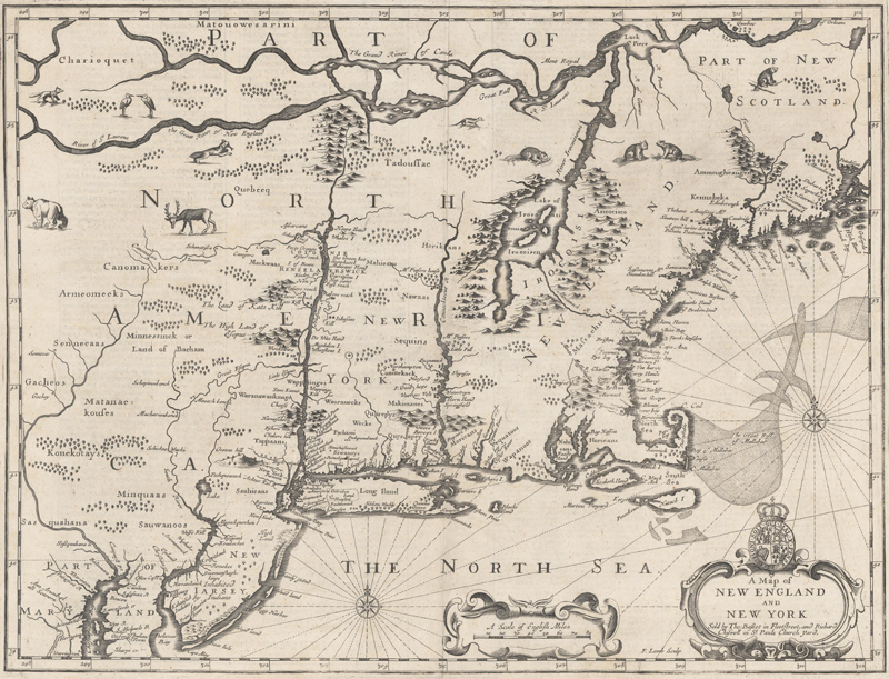
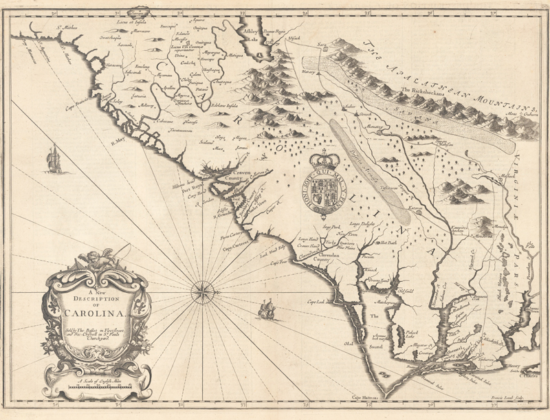
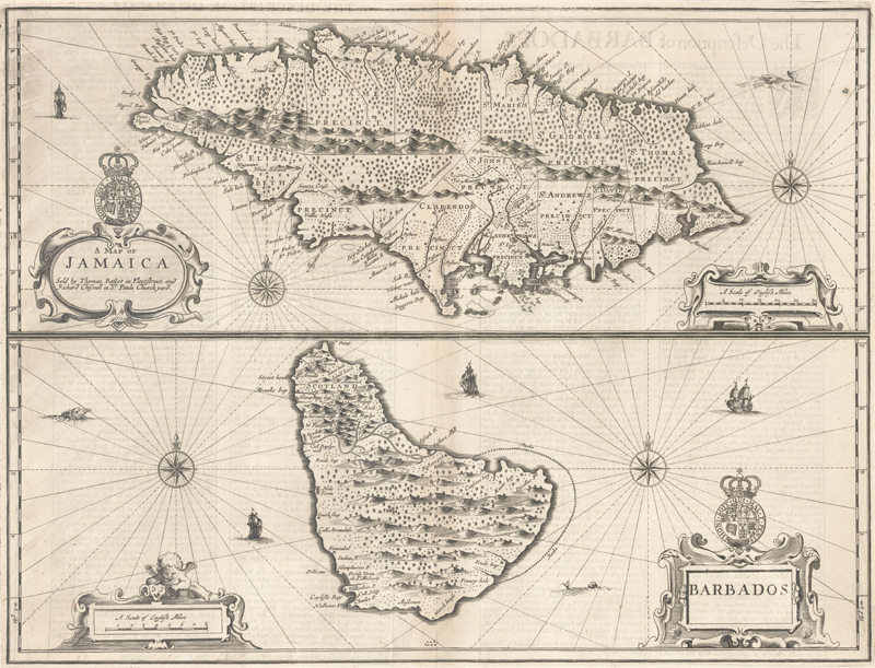
Of the various editions of The Theatre and Prospect, the William Humble editions are quite rare as they were published “in a rather haphazard fashion” (according to Baynton-Williams). The Roger Rea edition is also rare as many of the examples that were printed were destroyed in the Great Fire of London in 1666. However, the Basset & Chiswell edition is considered to be one of the most important, second only to the first edition, as it includes four maps of British Dominions that were newly engraved by Francis Lamb, as well as maps of the Great Mogul, East Indies, Russia, and Holy Land. Bassett and Chiswell recognized that the Prospect required some updating as they were issuing it 50 years after the maps had been originally engraved. In particular, the British possessions in North America were absent from the original set of maps, and so Lamb engraved maps of Virginia, New England, the Carolinas, and Jamaica and Barbados. The map of Virginia was based on Augustine Herman’s four-sheet map of 1673. The other three maps were based on John Ogilby’s maps in America, published in 1671, including the important “First Lord Proprietors Map” of the Carolinas. Although Bassett and Chiswell added their imprint to the original 22 maps in the atlas, they made few other updates to those maps. Basset and Chiswell published the last complete edition of The Theatre and Prospect that included both text and maps, however many of the maps were used in various atlases and collations through 1754 by Christopher Browne, Henry Overton, and Cluer Dicey.
The four maps that Francis Lamb engraved for the 1676 edition: Virginia, New England, Carolinas and Jamaica and Barbados. (Images courtesy of Old World Auctions)
John Speed was responsible for several other works during his lifetime. Circa 1603-04, he published an untitled four-sheet historical military map of England, Wales and Ireland that was engraved by Renold Elstrack. A complete copy of the map was unknown by historians until one was discovered by Günter Schilder in the Bibliotheque Nationale in Paris in 1986. This map served as a template for a folio-sized edition that was engraved for Speed by Cornelius Danckerts and was included in the Prospect in 1627, titled “The Invasions of England and Ireland.” Speed also published a map of the Holy Land ("Canaan") in 1611 in both folio and quarto versions, which were bound into issues of the King James Bible published at that time. The folio edition was engraved by Elstrack and it was closely copied for the quarto edition. Speed’s folio map of the Holy Land was curiously not included in the first edition of the Prospect, however Bassett and Chiswell rectified this for their 1676 edition, adding the map but with Elstrack’s name removed. Speed also created scripture genealogies for the King James Bible, even receiving a patent for the genealogies and map from the King. He expanded upon his biblical work and published several volumes of genealogies, including A Cloud of Witnesses: and they the Holy Genealogies of the Sacred Scriptures in 1616.
John Speed died in London on 28 July 1629. He survived his wife by one year, and they were buried side-by-side in London's Church of St. Giles, Cripplegate. A monument to Speed with a bust and an inscription was erected at the church, and although it was partially destroyed during World War II, an engraving of the monument was recorded in Thomas Smith’s Antiquities of London (1791). While the monument credits him with his contributions to history and cartography, it doesn’t convey the incredible influence that Speed’s works had on both his contemporaries and future generations. His books continue to be admired for their detail and comprehensiveness and his maps are prized among collectors for their iconography, town plans, historical elements, composition, and decorative embellishments. Today, John Speed is still considered to be one of the most important and famous figures of all English mapmakers, and his legacy endures with The Theatre of the Empire of Great Britaine and A Prospect of the Most Famous Parts of the World.