Subject: Exploration & Surveys
Period: 1782 (published)
Publication:
Color: Black & White
Size:
5.2 x 8.3 inches
13.2 x 21.1 cm
Pierre Marie Francois, Viscomte de Pages (1748-93), a French naval officer, completed a circumnavigation of the world and expeditions towards both the north and south poles between 1771-76. During the beginning of his circumnavigation of the world, Pages sailed to New Orleans and then along the Mississippi and Red Rivers to Natchitoches. Pages then traveled over land across present-day Texas and Mexico by the "Old San Antonio Road." After arriving in Acapulco, Pages continued his journey across the Pacific Ocean. This is the first edition of Pages' account of his travels, a two-volume set that includes 7 folding maps and 3 folding plates. Several later editions were published, including an English translation in 1792-93, however not all of the later editions included the maps and plates.
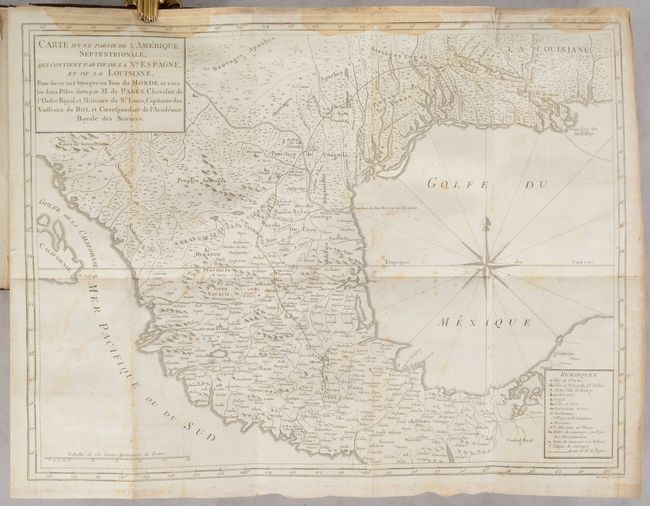
The key map from Pages' account is Carte d'une Partie de l'Amerique Septentrionale, qui Contient Partie de la Nle. Espagne... (16.8 x 12.7"), which shows Mexico and the southern United States and depicts the route of Pages, from the mouth of the Mississippi River to Acapulco, Mexico. Engraved by Benard, this map represents one of the most detailed depictions of the region at the time. In addition to Pages' route, there is excellent detail of villages, forts, missions, political boundaries, "huts of savages where there are missionaries," and "huts of savages that are not policed." Province de los Texas is labeled, surrounded by Indian lands. A fascinating and very rare map.
The additional maps are:
A. Carte Reduite du Globe Terrestre (13.3 x 10.7")
B. Carte d'une Partie des Cotes de l'Inde Depuis Bombay jus'qu'a Surate (16.1 x 9.4")
C. Carte d'une Partie de l'Asie, Depuis la Mer Mediterranee Jusqu'au Golfe de Cambaye dans la Mer de l'Inde (15.9 x 9.6")
D. Carte d'une Partie de la Syrie et de la Palestine (15 x 9.6")
E. Carte d'une Partie des Cotes des Isles Australes (15.9 x 9.8")
F. Carte du Spits-Berg, et Partie de la Cote de Galles Hams-Kes au Nouveau Groenland (19.3 x 12.7")
The three plates illustrate the dismemberment of a whale and two different sailing vessels. 12mo. Hardbound in contemporary French mottled calf, red and black morocco labels to spines, these richly gilt, marbled end papers.
References: Howes #P-13; Sabin #58168; Shirley (BL Atlases) G.PAGE-1a; Streeter (Texas) #1027.
Condition: B+
The maps and plates are issued folding with some misfolding, light soiling, occasional offsetting & foxing, and light dampstains. Several maps have a short binding tear, as is common. Both volumes have light dampstains along the top edge of the text, which otherwise has only minor toning and soiling. The covers of both volumes show light wear, and there is a crack at the top of the spine on Volume II.


