Subject: Colonial Southeast United States, Bahamas & Greater Antilles
Period: 1706 (circa)
Publication: Naaukeurige Versameling der Gedenk-Waardigste Reysen na Oost en West-Indien
Color: Hand Color
Size:
9 x 6 inches
22.9 x 15.2 cm
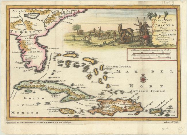
Scarce map of an unusually-shaped Florida, with the Carolinas north to Cape Hatteras and the western Caribbean. The map is based on the explorations of Lucas Vázquez de Ayllon, as reported to Alonso d'Ojeda, who explored the coast of South Carolina in 1526 with a retinue of 500 colonists, and settled near an area that was reportedly near the mouth of the Peede River. Ayllon died of ship's fever in 1526 and the remaining colonists abandoned the would-be settlement and straggled homeward to Hispaniola. The map derives its name from a native village on the South Carolina coast named Chicora, land of purported wealth and natural resources that Ayllon received a patent for from Charles V. In addition to Chicora, the fictional Lake May is shown, here named as Lac Grande. Cape Fear River is named as R. Jordan, and the native villages of Pomejoc and Secotan are noted along the Carolina coast. The cartouche is flanked by natives in a pastoral landscape.
References: Cumming (SE) #141.
Condition: A
Issued folding on a bright sheet with a tiny repaired hole along the right vertical fold.