Subject: United States & Canada
Period: 1862 (published)
Publication: H.R. Ex. Doc. 146, 37th Congress, 2nd Session
Color: Hand Color
Size:
5.8 x 8.9 inches
14.7 x 22.6 cm
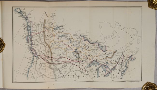
This disbound report and map were supplied to Congress by James Wickes Taylor, a special agent for the U.S. Treasury Department from 1859-69. Taylor saw the vast agricultural potential in the Canadian West, particularly the lands surrounding the Saskatchewan Valley and Red River of the North, and believed the region would be an ideal acquisition for the United States. At the time, the region was still part of Rupert’s Land, which was managed by the Hudson Bay Company and not under formal Canadian control. Included at the rear of the text is a folding map showing two possible routes for a transcontinental railroad – one in the Northern United States and another in southern Canada – along with an “Isotherm for Wheat,” which here seems to suggest the northern limit for growing wheat. A route through southern Canada would accelerate settlement and provide an easy way for transporting wheat to market. The text features a large section of Taylor’s Geographical Memoir of Northwest British America… which includes the history of the Hudson Bay Company, gold discoveries, and the future of trade in the northwest.
Despite Taylor’s exuberance to push the United States boundary farther north, Rupert’s Land was returned to Britain in 1870 (and Canada shortly thereafter) for £300,000.
References: Howes #T-56; Wagner-Camp #383b.1.
Condition: A
The folding map has a few spots of foxing, otherwise fine. Disbound text is clean and bright.


