Subject: Louisiana & Mississippi
Period: 1815 (dated)
Publication: A Military and Topographical Atlas of the United States
Color: Hand Color
Size:
21 x 15.4 inches
53.3 x 39.1 cm
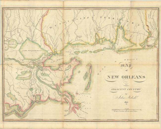
This scarce War of 1812 map was issued in the second edition of Melish’s A Military and Topographical Atlas of the United States. Melish first published a smaller atlas of the same title with 8 maps in 1813 and, due to popular demand, issued an enlarged version with 12 maps, including this map of the Gulf Coast. It highlights the Gulf Theater of War and extends from the vicinity of New Orleans east to West Florida. The map locates Fort Barancas (West Florida), Fort Bowyer (Mobile Bay), and military installations in Louisiana including St. Philip, St. John, and an "Old Fort" on Lake Ponchartrain. A "battle ground" is located about 5 miles to the east of New Orleans, which was the site of the Battle of New Orleans. This decisive battle, which took place 15 days after the peace treaty was signed (news did not spread in time), saw American forces repel a much larger British army in just 30 minutes time. The Americans suffered only 71 casualties compared to over 2,000 for the British, including their commanding general, Major General Sir Edward Pakenham. Longitude is measured from both Washington and London. We found only two past sales records for this map in the last 30 years.
References: Howes #M-492; Phillips (A) #1347; Ristow p. 181; Sabin #47432; Streeter (Sale) #83.
Condition: B+
Issued folding with light toning along the fold lines. A 3.5" binding tear at left and a few short fold separations have been archivally repaired on verso. The map is still attached to an endpaper on verso.


