Subject: Dakota Territory
Period: 1874 (dated)
Publication: Report of a Reconnaissance of the Black Hills of Dakota
Color: Black & White
Size:
21.4 x 25.1 inches
54.4 x 63.8 cm
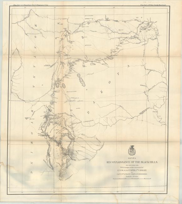
This is Ludlow's principle map that shows the entirety of Custer's reconnaissance of 1874. The map extends from Old Ft. Pierre on the Missouri River to the Little Missouri Buttes and north to the Badlands and the Yellowstone River. In the summer of 1874, Custer took units of his 7th Cavalry and 2nd Infantry Companies on a now famous march from Ft. A. Lincoln into the Black Hills of the Dakotas. On this expedition, gold was discovered, which led to the Black Hills Gold Rush, then to Custer's massacre and eventually to the tragic end of the Sioux War at Wounded Knee. This map traces Custer's route through the region of the Black Hills with the date of each encampment. The map contains many interesting notations, such as "Where they killed the Rees," "Where the sickman was killed" plus many comments on water, grasslands, springs, etc. The topography is nicely developed and portions of Raynold's 1859 route is shown.
References: Wheat (TMW) #1248.
Condition: B
Issued folding and now flattened and backed with linen to reinforce and repair a number of fold separations. There are light dampstains at top and bottom and some minor loss at a couple of fold junctions. The grayish color at the bottom of the image is caused by our scanner and is not present on the physical map.