Subject: Alabama
Period: 1874 (dated)
Publication:
Color: Black & White
Size:
16.9 x 43.6 inches
42.9 x 110.7 cm
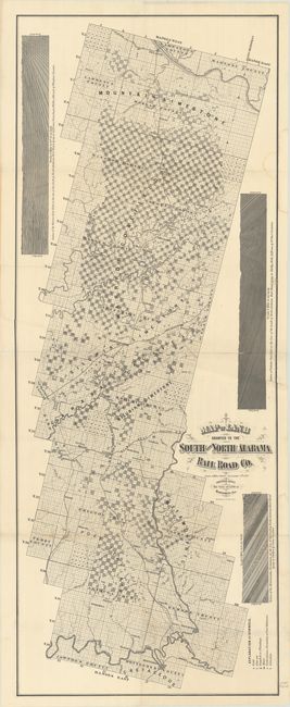
This rare and detailed map depicts an area of land approximate 50 miles wide and 160 miles long that was granted to fund construction of the South and North Alabama Rail Road. It stretches from Decatur along the Tennessee River south to Montgomery, and was issued shortly after the founding of Birmingham in 1871 (located at the center of the map). A legend at lower right reveals rich deposits of gold, iron, graphite, and more in an effort to attract buyers. Large bold text further markets the region including Silurian Limestone, Mountain Limestone and two large coalfields. It features 3 geologic cross-sections along the side borders and decorated by title with fancy lettering. We found no listings of this map on OCLC and only one other institutional example (Alabama State Archives).
The South and North Alabama Rail Road (also called the Alabama Central Railroad) was chartered in the 1850s, with construction completed in the 1880s. The railroad met the Alabama & Chattanooga Railroad at Birmingham shortly after the city's creation, and its population grew quickly as a result.
References:
Condition: B+
Issued folding on a clean sheet with archival repairs to a number of small fold separations. There is a light dampstain along the right border.