Subject: California
Period: 1948 (circa)
Publication:
Color: Printed Color
Size:
4.9 x 8 inches
12.4 x 20.3 cm
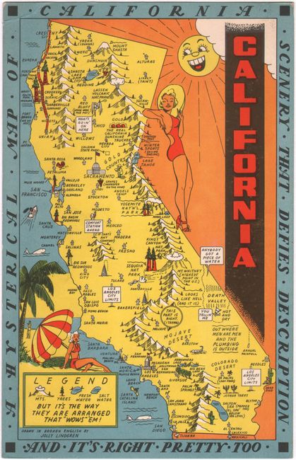
Visual puns and funny asides abound in this novelty map of California "drawn in broken English" by Jolly Lindgren. In Southern California, the Los Angeles city limits are shown reaching as far north as San Luis Obispo and as far east to the “Joshua Trees” while the region below Death Valley is “out where men are men and the plumbing is outside.” In Northern California, Gold Country is noted as “the real California sunshine” while the Redwood Highway has views that are both “crooked & scenic.” A legend at bottom identifies mountains, trees, fresh water, and salt water “but it’s the way they are arranged that ‘wows’ em!” The map is illustrated by a pair of female sunbathers and a bright sun emerging from the clouds. Printed on cardstock with "King Size Mapcard" printed on verso to allow tourists to mail this postcard to friends and family.
The Lindgren brothers of Spokane, Washington, specialized in humorous maps primarily of national parks. The brothers founded their business in 1928 with Hjalmer (Jolly) serving as the artist and Oscar (O.S.) overseeing administration and production. They produced their first map in 1932 - Hysterical Map of the Spokane Country Slightly Cockeyed - which was designed to be "hysterical" rather than "historical." Their comical map was successful, and in 1933 others followed, including Puget Sound, Rainier National Park and Yellowstone National Park. Despite the Great Depression, tourism in National Parks increased significantly in the 1930s, and visitors were eager for souvenirs of their trips. The Lindgren brothers capitalized on this trend, producing numerous National Park maps. Beginning with the Yellowstone map, Jolly developed a standardized format with a bold blue border incorporating the title, yellow denoting land (because of Yellowstone), red for roadways, black for text, and accents of green and blue. This style and color scheme became Jolly's signature style and was continued on all of his Hysterical maps of National Parks. The Lindgren brothers had hired Ted Turner as director of sales in 1930, and his role in the business gradually evolved until he became an official partner in 1949, and the business was renamed Lindgren-Turner. After World War II, the map business declined, so the Lindgrens and Turner innovated to create souvenir decals, which became hugely popular. After Jolly Lindgren's death in 1952, Oscar Lindgren and Ted Turner further extended the product line to include postcards (called "King Size Mapcard") as offered here.
References: Rumsey #11100.
Condition: A
Clean and bright with a tiny crease at top left.