Subject: Martha’s Vineyard, Massachusetts
Period: 1855 (dated)
Publication:
Color: Black & White
Size:
20.4 x 27.9 inches
51.8 x 70.9 cm
The Office of Coast Survey is the oldest U.S. scientific organization, dating from 1807 when Congress directed that a "survey of the coast" be carried out. By 1836, it was called the U.S. Coast Survey and in 1878, the name was changed to the U.S. Coast and Geodetic Survey. Today the Office of Coast Survey is a division of the National Oceanic and Atmospheric Administration NOAA.
The survey teams, composed of civilians as well as Army and Naval officers, charted the nation's waterways and produced a wide array of reports, survey charts, hydrographic studies of tides and currents, astronomical studies and observations, and coastal pilots. These charts are an important record of the changing nature of the nation's coastlines. In additional to coastal charts, the U.S. Coast and Geodetic Survey produced land sketches, Civil War battle maps, and the early aeronautical charts.
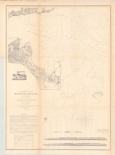
An early example of an excellent nineteenth century chart to show Martha’s Vineyard, Falmouth and the Nantucket Sound. Towns, villages, farms, and roads are all finely detailed along with hundreds of soundings, shoals and anchorages. At bottom are coastal approach views of Holmes’ Hole Harbor and the entrance to Muskeget Channel. Above the title is a finely rendered vignette showing the Cape Poge Lighthouse. Engraved by F. Dankworth, E. Yeager, J.V.N. Throop and J. Young. With the seal of the Coast Survey and signed in the plate by H.W. Benham.
References:
Condition: B+
Issued folding with some light toning along the folds. Binder's trim at lower left.