Subject: Northern New York
Period: 1931 (dated)
Publication:
Color: Printed Color
Size:
18.1 x 22.8 inches
46 x 57.9 cm
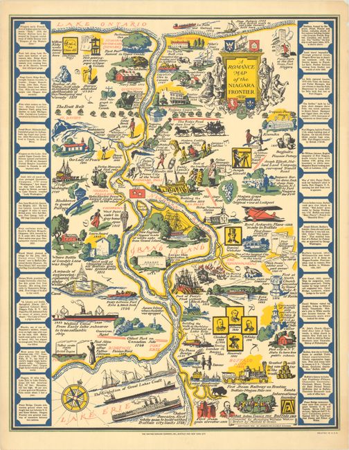
This gorgeous pictorial map covers the Niagara Frontier in between lakes Erie and Ontario. Compiled by Josephine Wilhelm Wickser and drawn by Mildred C. Green, it initiated the sequence of 9 "romance maps," many of which were compiled and/or executed by educated women with an interest in American history. The map is dense with charming illustrations emphasizing the historical attractions in the area. Among the images are "the Evolution of Great Lakes Craft;" portraits of Fillmore, Cleveland, McKinley, and Theodore Roosevelt; the burning of Buffalo in 1813; Ararat, City of Refuge on Grand Island; a West Point cadet in Chippewa; Father Hennepin beholding the Niagara Falls; an Iroquois peace house; the "greatest fur trading post in America;" and much more. A decorative title cartouche at top right incorporates a missionary, fur trappers, an Indigenous man, and emblems of the region. Panels of text at left and right provide more facts on the region. Published by the Whitney-Graham Company, Inc.
References: Hornsby (Picturing America) pp. 41-44 & plate 29 ; Rumsey #8309.
Condition: A
A colorful example with minor toning and a few small chips confined to the blank margins.