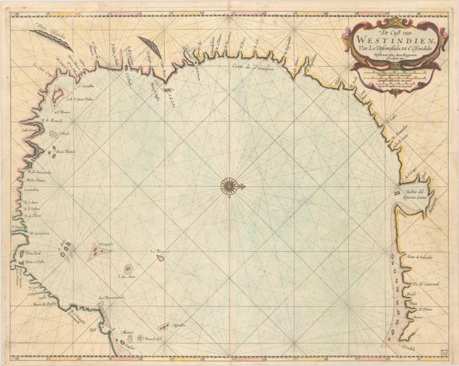
Subject: Western Gulf of Mexico, Texas
Period: 1680 (circa)
Publication: Het Eerste Deel Van het Brandende Veen…
Color: Hand Color
Size:
20.3 x 16.2 inches
51.6 x 41.1 cm
This rare Dutch sea chart covers the western Gulf of Mexico from the Yucatan Peninsula to approximately the Sabine River with north oriented to the right. According to Burden, it is one of the most important of Roggeveen’s charts and “the first Dutch one of the region and the most detailed chart of the present-day Texan coastline to date.” Like other Dutch charts of this period, the map is mostly derived from an exceedingly rare chart by Hessel Gerritsz, circa 1631. The chart reveals an evolving understanding of this stretch of coastline with many rivers, capes, offshore islands and shoals noted. The Rio Grande is here called R. Bravo and located directly above the Costa de Piscadores.
Arent Roggeveen, a land surveyor and mathematician, taught navigation for the Dutch East and West India Companies. He also helped maintain their collection of hydrographic manuscripts and charts. In the mid 1660s, Roggeveen compiled a series of large-scale sea charts of North America and the West Indies, which was published by Pieter Goos in Het Brandende Veen or The Burning Fen. This landmark atlas was the first Dutch pilot to focus on the Americas, with a number of regions mapped in larger scale than in any previously printed work. After Goos died in 1679, his widow sold the plates to Jacob Robijn, who reissued the maps with his name added to the title, as seen here. Both editions are extremely rare.
References: Burden #454; Shirley (BL Atlases) M.ROG-1b.
Condition: A
A crisp impression on a clean sheet with a few faint spots along the top border.


