Subject: United States
Period: 1842 (circa)
Publication: Letters and Notes on...American Indians
Color: Black & White
Size:
14.7 x 8.8 inches
37.3 x 22.4 cm
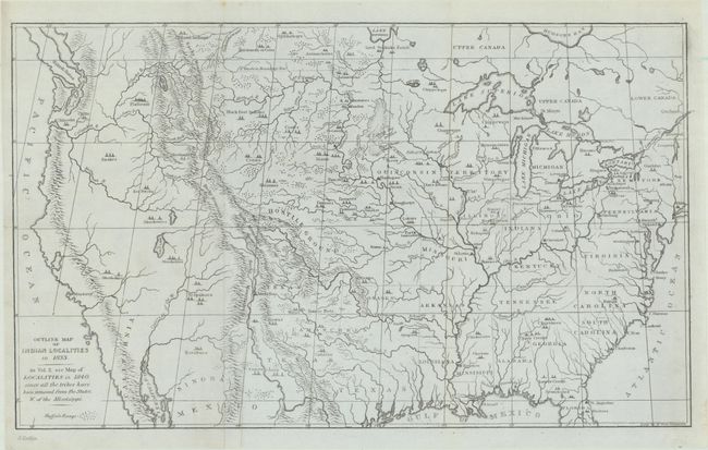
This great map was issued in an early edition Catlin's Indian Gallery. The map names scores of Indian villages, designated by tepee symbols. The map extends well into Canada, locating numerous Canadian tribes. There is good detail of watersheds and the known mountain ranges. The West is mostly blank and contains erroneous information in the Great Basin region derived from Fremont's map, including an east-west flowing river. An Independent Texas is shown with its northern border extending well into the Rocky Mountains, but it is indistinct at its upper reaches. Of special interest is the depiction of the Buffalo Range that stretches throughout the entire plains region and even into Mexico. The entire Midwest north of the Arkansas River and Texas is labeled "Hostile Ground". Includes the imprint of Catlin at lower left and page number 2 at upper right.
References: Wheat (TMW) #453; Howes #C-241; Wagner-Camp #84:5.
Condition: A
Issued folding on a clean sheet with a light vertical crease adjacent to the left fold.