Subject: United States, Civil War
Period: 1862 (circa)
Publication: The War in America
Color: Hand Color
Size:
16.8 x 10.7 inches
42.7 x 27.2 cm
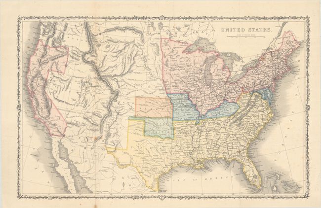
This early edition map of the United States was published near the beginning of the Civil War. It is color-coded to show the Union states, Confederate states, border states, and Indian Territory. Kansas is its own color (orange), likely due to its just having been admitted to the Union in 1861. In addition to the conflict in the eastern states, the map shows some evolving western territorial configurations including Washington in its short-lived "L" configuration, Dakota Territory encompassing present-day Montana, Utah Territory taking up western Nevada, and New Mexico Territory occupying southern Nevada. Arizona is shown occupying the southern section of New Mexico territory, likely referencing the Confederate Territory of Arizona. The detailed map shows railroads, rivers, topography and the Missouri Compromise Line running to the Pacific Ocean. This early example does not include the color-coded legend at top or the publisher's name. Surrounded by a decorative vine and flower border. The War in America was written by American Taliaferro Preston Shaffner and published in London by London Printing & Publishing.
References: Howes #S-321.
Condition: B+
Issued folding with minor foxing.