Subject: United States
Period: 1879 (dated)
Publication:
Color: Printed Color
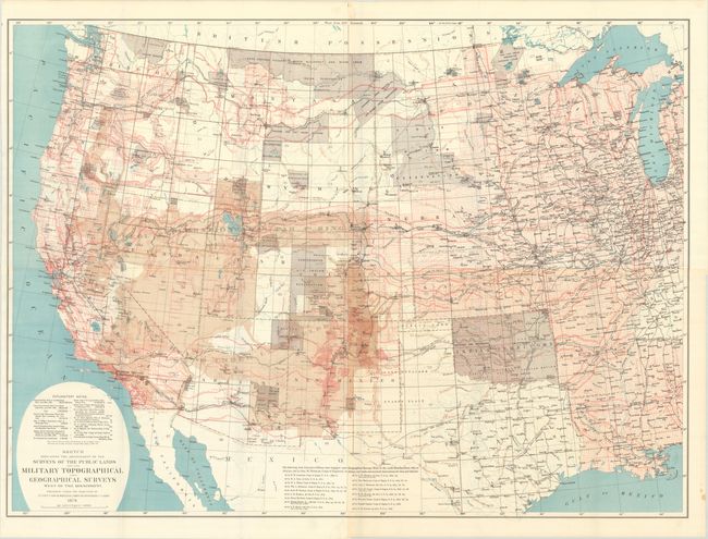
A. Sketch Indicating the Advancement of the Surveys of the Public Lands and the Military Topographical and Geographical Surveys West of the Mississippi... (44.5 x 32.6"). Large scale, beautifully lithographed in four colors with impressive detail throughout. The map locates more than 130 forts and camps (many flying tiny American flags), nearly 70 Indian reservations, the routes of dozens of early explorers, completed and projected railroads with their land grants, and dozens of Spanish land grants noted. Survey details plotted include base lines, meridians and townships. Wheeler's extensive surveying efforts in the Southwest are indicated by shading, as are Clarence King's along the 40th parallel. The map consists of four joined sheets.
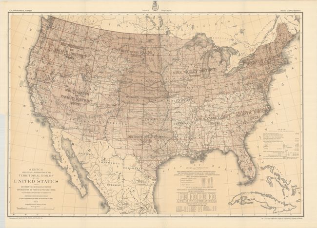
B. Sketch Indicating a Distribution of the Territorial Domain of the United States into Districts Favorable to the Operations of Parties Prosecuting General Government Surveys... (28.5 x 19.8"). This map is an effort to set out a systematic plan for the scientific mapping and survey of the country. It shows Wheeler's comprehensive plan, proposed in the report, for surveying the entire U.S. in eight districts in 210 rectangular grids, applying the same scientific standard throughout. In fact, this is the same method Wheeler used in his earlier western surveys. The underlying map has excellent topographic and political detail. A surprisingly handsome and important map in the history of the surveying of the United States.
References:
Condition: A
Issued folding on clean bright sheets. Both maps have old stamps on verso for "Intelligence Division - War Office" dated June 1890. The second map has a binding trim at left.