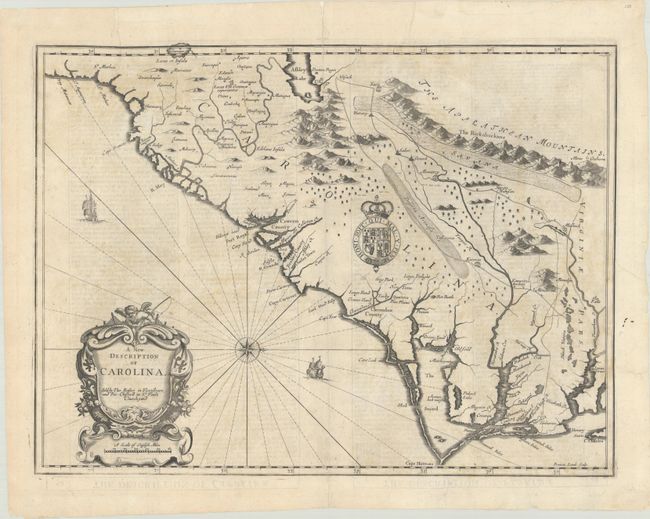
Subject: Colonial Southeastern United States
Period: 1676 (circa)
Publication: A Prospect of the Most Famous Parts of the World
Color: Black & White
Size:
19.8 x 14.8 inches
50.3 x 37.6 cm
This striking map of the Southeast region was based on the landmark Lords Proprietor's Map of 1672 by Ogilby/Moxon. It incorporates information from a number of early accounts including Lederer, Hilton, Sandford, Ashley-Cooper, and Culpeper. Oriented with north to the right as indicated by the compass rose, the map covers the region from St. Augustine to Cape Charles and Jamestown with detail focused along several rivers. The fictitious Ashley Lake, Deserta Arenosa, and a Savana east of the Apalathean Mountains are of particular interest. It is artistically embellished with graphic mountain ranges, the arms of Charles II, ships, and a title cartouche with a fishing putto. English text on verso contains an interesting account of John Lederer's important explorations. Speed's atlas was the first world atlas produced wholly in England. It was first published in 1627 without any maps of the American colonies. It was not until the last edition (47 years after Speed's death), by Thomas Bassett and Richard Chiswell, that the new maps of America, engraved by Francis Lamb, were added.
References: Cumming (SE) #77; Goss (NA) #41; Shirley (BL Atlases) T.SPE-2f #26.
Condition: B
A nice impression on a watermarked sheet with light, scattered stains and archivally repaired centerfold separations at top and bottom. There are several extraneous creases and a few short edge tears. The text on verso is printed upside down, and there are remnants of hinge tape on verso.