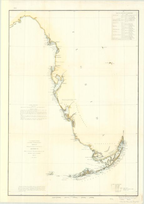
Subject: Western Florida
Period: 1848-51 (dated)
Publication:
Color: Hand Color
Size:
16.3 x 23 inches
41.4 x 58.4 cm
The Office of Coast Survey is the oldest U.S. scientific organization, dating from 1807 when Congress directed that a "survey of the coast" be carried out. By 1836, it was called the U.S. Coast Survey and in 1878, the name was changed to the U.S. Coast and Geodetic Survey. Today the Office of Coast Survey is a division of the National Oceanic and Atmospheric Administration NOAA.
The survey teams, composed of civilians as well as Army and Naval officers, charted the nation's waterways and produced a wide array of reports, survey charts, hydrographic studies of tides and currents, astronomical studies and observations, and coastal pilots. These charts are an important record of the changing nature of the nation's coastlines. In additional to coastal charts, the U.S. Coast and Geodetic Survey produced land sketches, Civil War battle maps, and the early aeronautical charts.
This informative chart of Florida's western coast is based on the surveys of F.H. Gerdes of the U.S. Coast Survey and a sketch map by Capt. John C. Casey of the U.S. Army Corps of Topographical Engineers. It shows the original triangulations that were the basis for all later surveying of Florida. The chart details the coast from the Suwanee River south to the Keys. It identifies several forts, bays, reefs, and capes, and notes "Dense forest of Cypress & Pine broken by Tracts of Prairie & Swamp" near Sarasota, an Indian district, and "Indian Hunting Grounds" to the southeast of White Water Bay. The eastern coast is only vaguely defined by a dotted line, with only Mosquito Inlet and Cape Canaveral named. The chart includes sailing directions for Tampa Bay and Charlotte Harbor, a table of latitudes and longitudes, and a key locating various stations.
References:
Condition: A
A bright example, issued folding, now flat and backed in archival tissue to repair a few short fold separations. The binding trim at left has been replaced with paper.