Subject: Hawaii
Period: 1950 (dated)
Publication:
Color: Printed Color
Size:
28.2 x 18.8 inches
71.6 x 47.8 cm
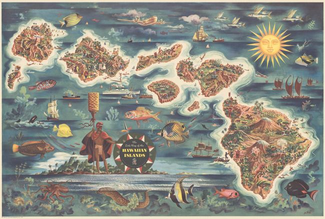
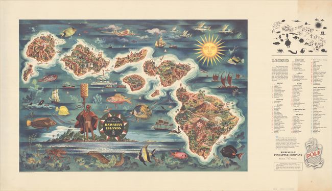
This vivid and graphic map of the Hawaiian islands was published by the Hawaiian Pineapple Co., Ltd. and drawn by Joseph Feher. It depicts each of the eight major islands, and is filled with illustrations highlighting Hawaiian culture and points of interest. Unlike earlier versions, this edition includes a legend with over 100 points of interest that are keyed to the silhouetted map above (for ease of identification on the busy and colorful main map). The legend was intended to be cut away and pasted on the verso of a framed example. A sampling of the illustrations include the landing of Captain Cook on Kauai, Pearl Harbor and Dole Cannery on Oahu, Mauna Kea Volcano and the Mark Twain tree on Hawaii, and many more. The surrounding seas are filled with wonderful illustrations of fish, an octopus, a whale, and numerous ships including a pineapple barge. The title is enclosed in a decorative compass rose at center. Lithographed by Schwabacher-Frey.
References:
Condition: B+
The map image is crisp and vivid. There is light toning along the right edge that enters into the key. The map has been tightly rolled and does not lay flat on its own.