Subject: World
Period: 1872 (published)
Publication: La Vie Parisienne
Color: Black & White
Size:
19.4 x 12.6 inches
49.3 x 32 cm
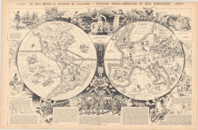
This fascinating map gives the French perspective on two important political events of international importance: the Alabama Claims and the Franco-Prussian War. The Alabama Claims, so named for Confederate raider CSS Alabama, were reparations demanded by the United States from the United Kingdom due to the latter's involvement in supplying warships to the Confederacy during the US Civil War. The supply of the ships violated Britain's neutrality, and although the British government was not directly involved in the building or selling of the ships, they were knowledgeable of the situation and did little to prevent it. Two of the warships, CSS Alabama and CSS Florida, successfully captured or sank over 100 Union ships during the Civil War. After the war, the US government sought $2 billion in damages from Britain due to the casualties and loss of supplies the Union suffered as a result of the British-built ships. This map was published shortly after the US and UK agreed to international arbitration regarding the Alabama Claims, which were finally settled in September 1872 by the Treaty of Washington with the US being awarded $15.5 million in compensation (approximately equal to $33 billion today).
France was annoyed at the United States' enormous request of reparations, as evidenced by the vignette at top center in which Abraham Lincoln holds up Britannia at gunpoint with a list of demands, and several comments surrounding the map allude to the greed of the US. However, France was certainly more irritated at Britain's neutrality during the Franco-Prussian War, which had ended the year before this map was published. Many political leaders in Britain believed that a stronger Prussia might be a benefit, however they likely underestimated the amount of power Prussia would gain, especially after unification with the independent German states. The result was a huge shift of power on the European continent from France to Prussia, which is illustrated on the map by each country identified as "Ex-" (such as Ex-France) and the entire continent unified within a fortified border under Wilhelm I, the "regenerator" of Europe.
Other interesting imagery on the map include: President Abraham Lincoln holding up the western hemisphere while Wilhelm supports the eastern hemisphere; trans-Atlantic train tracks connecting France with the United States, Cuba and South America, along with numerous train lines criss-crossing North and South America; and a vignette at bottom center with Wilhelm I hoarding bundles of money, Alsace and Lorraine (which France had lost due to the war), the independent German states, and Belgium.
This double-page map was published in the March 9, 1872 issue of La Vie Parisienne, which was a weekly publication that included short stories, articles, illustrations, and gossip.
References: PJ Mode Collection #2145.
Condition: B+
There are a few spots of foxing, a soft horizontal crease, and light toning along the edges of the sheet.