Subject: Colonial New York & Vermont
Period: 1782 (circa)
Publication: Essais Historiques et Politiques sur les Anglo-Americains
Color: Hand Color
Size:
15 x 7.8 inches
38.1 x 19.8 cm
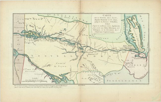
This uncommon Revolutionary War map was published in Michel-Rene Hilliard d'Auberteuil's Essais Historiques et Politiques sur les Anglo-Americains. It is centered on the Hudson River Valley with north oriented to the left, extending from Fort Chambly and St. Jean south to New York City. While most of the map is labelled New York, a good portion of the map to the east of the Hudson River would soon become Vermont. Details include early settlements, forts, and roads primarily along the Hudson River, along with Fort Stanwix off of Lake Ontario. A note below the bottom border states that Colonel Leger (British Army) set out from Montreal to take Fort Stanwix (in August 1777) but abandoned the siege and returned by the same route. Leger's retreat played an important role in the Saratoga Campaign as he was unable to join forces with General Burgoyne, who surrendered at the Battle of Saratoga in October 1777.
References: Howes #H-493; Sabin #31899.
Condition: B+
A nice impression on watermarked paper with light toning along the centerfold and sheet edges. A short centerfold separation in the top blank margin has been closed on verso with archival tape.