Subject: Beaufort, North Carolina
Period: 1854 (dated)
Publication:
Color: Black & White
Size:
29.5 x 22.5 inches
74.9 x 57.2 cm
The Office of Coast Survey is the oldest U.S. scientific organization, dating from 1807 when Congress directed that a "survey of the coast" be carried out. By 1836, it was called the U.S. Coast Survey and in 1878, the name was changed to the U.S. Coast and Geodetic Survey. Today the Office of Coast Survey is a division of the National Oceanic and Atmospheric Administration NOAA.
The survey teams, composed of civilians as well as Army and Naval officers, charted the nation's waterways and produced a wide array of reports, survey charts, hydrographic studies of tides and currents, astronomical studies and observations, and coastal pilots. These charts are an important record of the changing nature of the nation's coastlines. In additional to coastal charts, the U.S. Coast and Geodetic Survey produced land sketches, Civil War battle maps, and the early aeronautical charts.
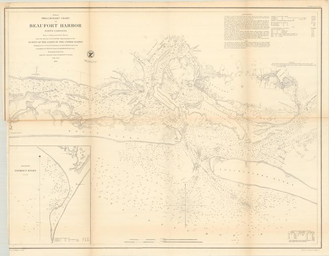
A highly detailed chart including Beaufort, Fort Macon, Bogue Sound and Banks, Shackleford Banks, and more. The waters are teeming with navigational detail including soundings, ground types, shoals, offshore islands, and sailing directions. On land, the street-grid pattern of Beaufort is laid out with individual buildings located. An inset of Lookout Bight is featured at lower left. Engraved by J.V.N. Throop and J.B. Metzeroth. With the seal of the Coast Survey and signed in the plate by H.W. Benham.
References:
Condition: B+
Issued folding and trimmed to inside the border at lower left by the binder. There is light toning along the horizontal fold and one short archivally repaired fold separation.