Catalog Archive
Auction 198, Lot 244

Centennial Exposition Multilingual Map of Philadelphia

"Map of the Compact Portion of Philadelphia Prepared for Gopsill's Directory [on sheet with] Outline Map of the County and City of Philadelphia and Vicinity", Gray, Ormando Willis & Son

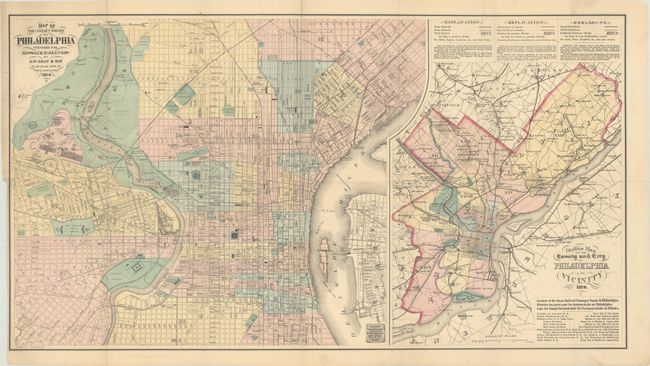
Subject: Philadelphia, Pennsylvania

Period: 1876 (dated)

Publication:

Color: Hand Color

Size:
29.9 x 16.3 inches
75.9 x 41.4 cm
Download High Resolution Image
(or just click on image to launch the Zoom viewer)

Two detailed maps on one sheet. At left is a street map of the city of Philadelphia extending as far west as Fairmount Park, the site for the Centennial Exposition celebrating the Declaration of Independence. At right is a map of the surrounding region, including the suburbs of Chestnut Hill, Germantown, Frankford, and Camden. The legend for this map, which locates various railroads and city wards, is written in English, French and German in order to appeal to a global audience. The Centennial Exposition was the first World’s Fair hosted in the United States. Nearly ten million people attended from around the world.

References:

Condition: B+

Issued folding with archival repairs to a couple of separations along the horizontal fold and two short edge tears at left. There is some faint offsetting and a minor crease at right.

Estimate: $140 - $170

Sold for: $70

Closed on 6/19/2024

Archived