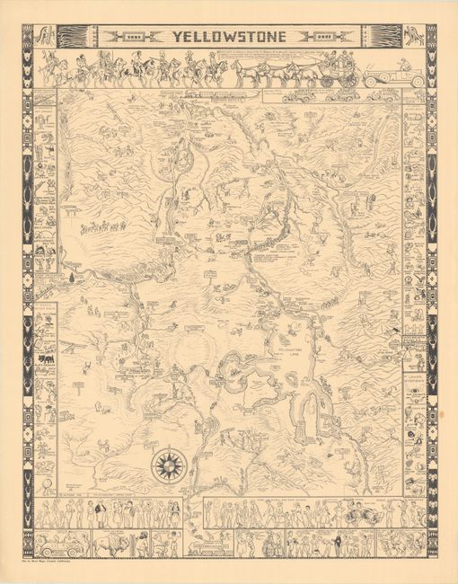
Subject: Yellowstone National Park, Wyoming
Period: 1931 (dated)
Publication:
Color: Black & White
Size:
20.1 x 25.8 inches
51.1 x 65.5 cm
This is the first printed edition of Jo Mora's brilliant pictorial map of Yellowstone, printed in black & white and in a larger format than the later color editions. It is one of three maps he created showcasing American national parks. Mora's dedication on this map reveals the heart of reverence underlying his cartoon rendering of the park: "This carte is cordially dedicated to Horace M. Albright - Director U.S. National Park Service - with hopes that its humor may add whimsical seasoning to his splendid record in making glorious Yellowstone the facile pageant it is today." The landscape is teeming with illustrations, with the park's landmarks depicted in a series of goofy visual puns. The border of the map incorporates the classic imagery of the American West and Indigenous cultures, recurring tropes in Mora's work. Along the sides of the map are panels stuffed with more visual jokes of the sights to be seen at Mammoth Hot Springs, Norris Geyser Basin, Upper Geyser Basin, and Lower Geyser Basin. Mora gently caricatures the various "sage brushers and dudes" that come through Yellowstone and includes playful vignettes of bears sticking up a motorist and a tourist face-to-face with a buffalo on the other side of a fence. This is pictorial mapmaking at its very best, an exuberant and terrifically executed design. Imprint at bottom left reads "The Jo Mora Maps, Carmel, California."
Joseph ("Jo") Jacinto Mora was born in Uruguay in 1876 and moved the following year with his family to the eastern United States. He showed an early aptitude for the arts and began illustrating for newspapers and children's books in his twenties. Mora was fascinated with the American West, and after working on cattle ranches in Texas and Mexico as a young adult, he moved permanently out west in 1903. He spent his time learning about old Spanish vaqueros, American cowboys, and the Hopi and Navajo tribes, subjects which became lifelong passions and the focus of much of his work. His paintings and photographs of the Hopi were memorialized into a traveling exhibit for the Smithsonian Institution in 1979.
Mora was an artist with many talents, including drawing, painting, illustration, sculpture, photography, writing, and mapmaking. His artistic skills were perhaps unsurprising, as his father was a noted sculptor, and Jo Mora on occasion helped his father on sculpting commissions, including the facade of the Native Sons of the Golden West Building in San Francisco. His foray into mapmaking began later in his career while he was residing in Pebble Beach, California, where he would spend the last 27 years of his life. Mora's first map was of the Monterey Peninsula, entitled California's Playground, and was commissioned by the Del Monte Hotel to commemorate the hotel's grand reopening in 1926. The map combined historical facts with whimsical illustrations, cartographic points of interest, cartoonish figures, and witty notations. And thus was born Mora's unique style that is common on all of his "cartes," a term that he used for his cartographic works. Although Mora only created about a dozen maps in his career, Stephen J. Hornsby contends that "His maps formed the most important collection of pictorial cartography done by any artist of one particular region of the United States" (Hornsby, p. 29).
Provenance: collection of Peter Hiller. The map is accompanied by a letter of provenance signed by Hiller, Jo Mora Consultant and author of The Life and Times of Jo Mora: Iconic Artist of the American West.
References: Hornsby (Picturing America) pp. 28-31; Rumsey #8536.
Condition: A
A crisp example on a faintly and pleasantly toned sheet with a small light stain in the right blank margin and minor creasing along the edges of the sheet.


