Subject: Southeastern Jamaica
Period: 1894 (dated)
Publication:
Color: Black & White
Size:
36.8 x 25.4 inches
93.5 x 64.5 cm
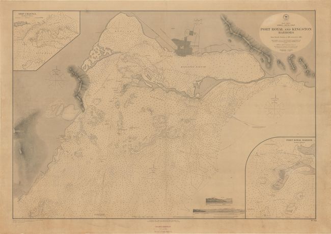
This large sea chart covers the Jamaican coast from Wreck Bay to Bull Bay, with emphasis on Port Royal and Kingston Harbor. Kingston is depicted in miniature plan form, with Allman Town, the race track (now National Heroes Park), churches, and the road and railway to Spanish Town identified. There is good topographical detail around Great Salt Pond and Long Mountain. The chart is teeming with navigational information, including depth soundings, cays, shoals, lighthouses, breaks, and more. An inset at top left details the ship channel near Fort Augusta, and another inset at bottom right zeroes in on Port Royal Harbor. Coastal views at bottom show Salt Pond Hill and the hilltop notch where the Fort Augusta and West Middle Rock beacons nearly align. An exquisitely detailed chart, based on British surveys. Originally published in 1882, a stamp at bottom notes that the chart has been corrected to November 22, 1894.
References:
Condition: B
A crisp impression on a toned sheet that has been mounted on heavy linen, repairing separations along the centerfold and a 12" edge tear at left. There are a few small stains.