Subject: Central South America, Peru
Period: 1705 (published)
Publication: Description de Tout l'Univers...
Color: Hand Color
Size:
11 x 8.1 inches
27.9 x 20.6 cm
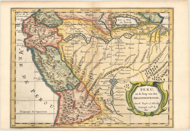
This handsome map of the western part of the continent shows the full course of the Amazon. The spurious Lac, ou Mer de Parime is prominent as is the location of the mythical city Manoa el Dorado (city of gold). It is fully engraved to show topography, cities, and villages and decorated with an attractive strapwork title cartouche. Although his imprint does not appear on this map, this map was re-engraved from Sanson's 1657 map by Antoine de Winter. Published in Francois Halma's Dutch edition of A. Pherotee de la Croix's Nouvelle Methode Pour Apprendre facilement la Geographie Universelle.
Sanson's small maps from his L'Amerique en Plusieurs Cartes..., first published in 1657 and engraved by A. Peyrounin, were copied several times by various map publishers. Johann David Zunners made copies of Sanson's maps for his German translation of Die Gantze Erd-Kugel in 1679. Johannes Ribbius and Simon de Vries published copies in 1682 and 1683, with new maps engraved by Antoine d'Winter. The plates were later sold to Francois Halma, who used them in 1699 and then again in 1705 with the titles re-engraved in Dutch. The titles on the d'Winter plates were re-engraved back into French, and then used by Nicholas Chemereau in 1715 and by Henri du Sauzet in 1738.
References:
Condition: B+
A fine impression on a sheet with Amsterdam coat of arms watermark. There is light toning along the centerfold and a centerfold separation that enters 0.5" into map image at top and has been closed on verso with archival tape.