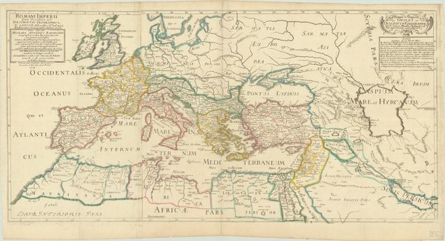
Subject: Europe & Mediterranean, Roman Empire
Period: 1703-04 (dated)
Publication:
Color: Hand Color
Size:
31.7 x 15.8 inches
80.5 x 40.1 cm
This handsome map covers the entire Roman Empire, including most of Europe, Northern Africa, and the Near and Middle East, and is filled with ancient place names. It is printed on two sheets and joined, as issued. This map is a re-engraved edition of Nicolas Sanson's 2-sheet map of the Roman Empire, published by his grandson, Pierre Moullart-Sanson. Nicolas Sanson's map was first published in 1637 by Melchoir Tavernier and Pierre Mariette. In 1684, Sanson's son, Guillaume Sanson, reissued the map with the addition of text accusing French geographer Michel Antoine Baudrand of plagiarism, explaining that Baudrand had copied Sanson's map and claimed it as his own in 1669. Moullart-Sanson re-engraved the map, simplifying the cartouche on the western sheet and maintaining Guillaume Sanson's declaration of plagiarism.
References:
Condition: B+
Contemporary outline color on two sheets, joined, with a large watermark of a French coat of arms. There is light soiling, a bit of toning where the sheets were joined, and an abrasion at right with small loss of the neatline. There are several short tears along the edges of the sheet that have been closed on verso with archival tape.