Subject: Europe, World War I
Period: 1915 (circa)
Publication: L'Europe Anti-Prussienne
Color: Printed Color
Size:
10.2 x 5.9 inches
25.9 x 15 cm
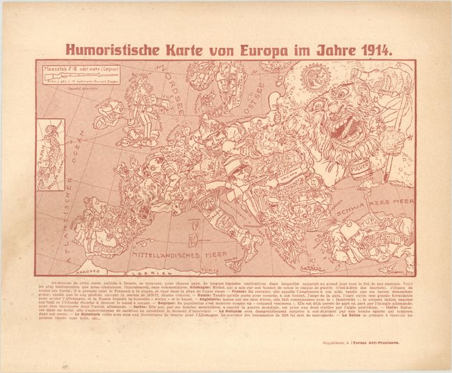
This is a reduced-size edition of Karl Lehmann-Dumont's political caricature map of Europe depicting the continent at the outbreak of World War I. The map depicts the Germans' view of the alliance situation and territorial issues towards the end of the first year of the war. The key countries involved in the war are represented by human caricatures with various props that help illustrate the situation. This edition was published as a supplement to L'Europe Anti-Prussienne, a French magazine that published cartoons that were typically from the perspective of the Allies. Below the map is French text explaining that the map shows the "gall of our enemies" and includes direct translations of some of the German text that had been included on Lehmann-Dumont's original map to describe each country's "character."
Germany is described as a Deutsche Michel (an ordinary or average German), stretching and extending himself with all his might, already grasping the Frenchman by his throat and punching the Russian bear. Germany's Imperial Eagle unleashes bees from their hive to attack its enemies, which appear on the map as both bees and missiles. France, already covered in bees, appears to retreat, and calls to England for help. Meanwhile, the French rooster crows about its victories in the battles from 1870-71 (Franco-Prussian War). The giant Russian bears an "Angel of Peace" symbol on his cap, with a bottle of Vodka in one hand and a whip of "revolution" in the other hand. The Russian opens his mouth wide in an attempt to swallow Germany and Austria whole, but is deterred by the German bees. England, who has caused Egypt to declare war, stands on bags of money while being punched in the face by an iron fist. The English bulldog finds it difficult to breathe with an Indian snake wrapped around its neck. The Englishman has also dragged Japan into the war, and holds a string that is attached to Japan, depicted in an inset at left. Numerous other intricate relationships and symbolic references fill the map.
References: cf. Curtis & Pedersen (War Map) pp. 32-35; cf. PJ Mode Collection #1174.01.
Condition: B+
Printed in red ink with a faint dampstain at bottom left and marginal toning.


