Subject: Germany
Period: 1935 (dated)
Publication:
Color: Printed Color
Size:
16.3 x 12 inches
41.4 x 30.5 cm
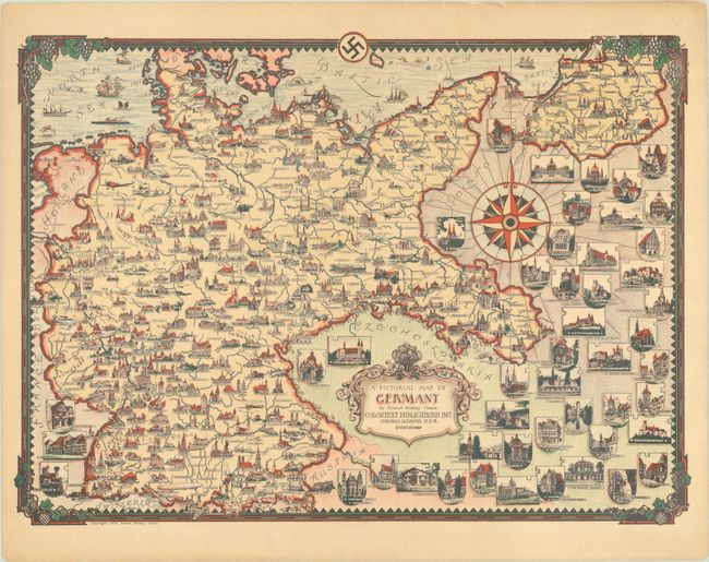
This pictorial map of Nazi Germany is one of the earliest works by Ernest Dudley Chase (1878-1966), one of the leading figures in pictorial mapmaking during the middle 20th century. It was part of a series of Story Maps published in Chicago by Colortext Publications Inc. between 1935-50. The map depicts Germany extending into Pomerania, Silesia, and East Prussia. Towns and cities are accompanied with miniature illustrations of buildings of note, with additional architectural vignettes filling the surrounding countries. The map is surrounded by a grapevine border, with the Nazi swastika at top casting the dark shadow of history over the map. We have identified five other variants of this map, all dated 1935: another Colortext issue with a more muted color palette; a black & white Colortext issue; a black & white issue published by Chase himself with a reverse swastika; another black & white Chase issue with the Federal Eagle (suggesting a post-war publication date); and a similar example with an altered Federal Eagle and color in the compass rose.
References: Hornsby (Picturing America) pp. 31-34; Rumsey #10731.
Condition: B+
A colorful example on a lightly toned sheet with minor creasing and a few short edge tears, including one that enters 0.5" into map image at top and has been closed with archival tape on verso.