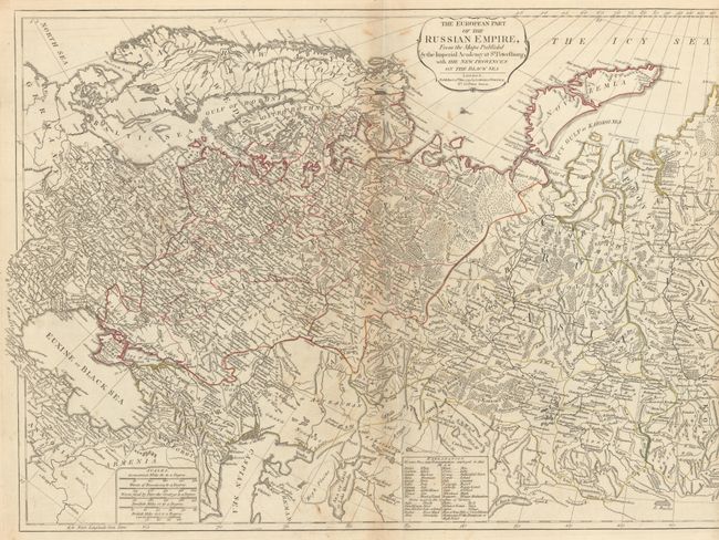
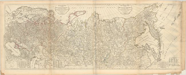
Subject: Russia
Period: 1794 (dated)
Publication: A New Universal Atlas...
Color: Hand Color
Size:
50.6 x 19.1 inches
128.5 x 48.5 cm
This tremendously detailed map that covers the whole of Russia has been updated to show Russia's new provinces on the Black Sea and information from Capt. Cook's exploration of Kamchatka. The map was first issued in 1772 by Robert Sayer with a conjectural Alaskan Peninsula and an entirely different configuration for Kamchatka. A network of roads appear in northern Asia. In the Sea of Okhotsk, the track of the 1777-78 exploration of Pilot Petuszcoff is delineated. Sakhalin Island (here shown as Isle Sagaleen and Ezzo) and Hokkaido (Matmay) are roughly indicated. A note on Bering Island remarks on the explorer's death in 1741. This edition was compiled from the maps of the Imperial Academy at St. Petersburg. Five distance scales and extensive legend explains Russian and Tartarian terms used in the map. The map is printed on two, joined sheets (as issued).
References: Shirley (BL Atlases) T.LAU-1a #37.
Condition: B+
Contemporary outline color on watermarked paper with minor foxing and a couple of creases adjacent to the folds. There are a few short edge tears and small edge chips at lower right that have been backed with tissue.