Subject: Western Hemisphere - America
Period: 1746 (dated)
Publication:
Color: Hand Color
Size:
24.9 x 19.3 inches
63.2 x 49 cm
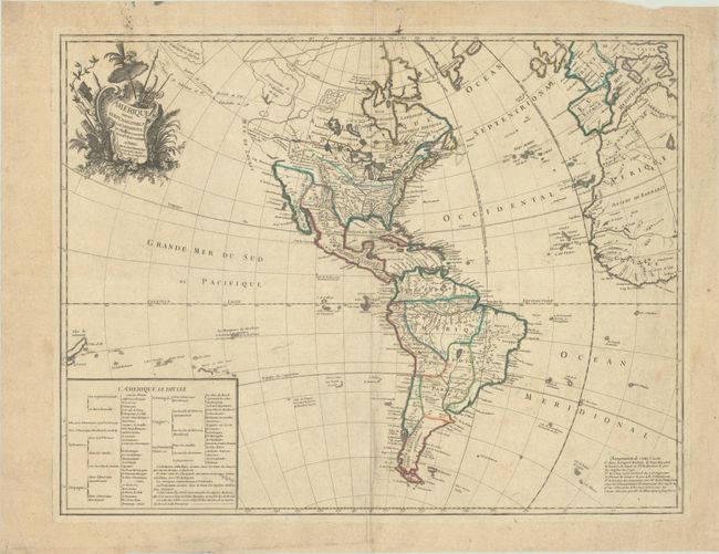
This fascinating map illustrates some of the most interesting mythical cartography juxtaposed with important new discoveries in North America. The routes of Delisle and Tchirikow are shown in 1741 terminating on a vague island in the approximate location of Alaska. A Northwest Passage (shown by lightly engraved lines) links the Pacific with Hudson Bay where there is a note concerning the British discoveries of 1742. The Riv. de l' Ouest stretches from Lake Superior nearly to the Pacific, based on the reports of the Jesuit missionary, Pierre de Charlevoix. In South America the Amazon River is detailed according to Charles Marie de la Condamine's expedition. This is a very early record of Condamine's incredible 10-year adventure from 1735-45; his journal of the expedition was not published until 1751. A text table lists the colonial possessions. McGuirk identifies this as the second state, but we have since found an earlier example that does not include the note at bottom right regarding changes to the map's cartography, so this is more likely the third state, published circa 1753.
References: Map Collector #64, p. 18-23; McGuirk #15.
Condition: B+
Contemporary outline color on a lightly toned sheet with a large watermark of a Maltese cross encircled in rosary beads. There is light soiling, a printer's crease at top center, an extraneous crease at bottom center, and several ink stains in the top margin.