Catalog Archive
Auction 198, Lot 571

"[Asia Minor] Tabula Haec Multarum Regionum Situm, quas Quidem Solinus Praesenti hoc Capite & non Nullis Sequentibus Describit, Exprimet", Solinus, Caius Julius

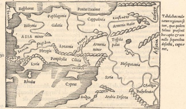
Subject: Middle East & Cyprus

Period: 1538 (published)

Publication: C. Iulii Solini Polyhistor...

Color: Black & White

Size:
5.3 x 3.7 inches
13.5 x 9.4 cm
Download High Resolution Image
(or just click on image to launch the Zoom viewer)

This scarce woodcut map by Sebastian Munster was published in Solinus' Polyhistor. It depicts Turkey and the Holy Land with ancient place names, exaggerated rivers, and rope-like mountains. On a sheet of Latin text measuring 7.9 x 12.4".

Solinus was a Roman grammarian from the 3rd century who borrowed largely from Pliny's Natural History, reinterpreting it from a geographical perspective.

References: Mickwitz & Miekkavaara #285-13.

Condition: A

A nice impression on a bright sheet with minor soiling in the bottom margin.

Estimate: $200 - $230

Sold for: $150

Closed on 6/19/2024

Archived