Subject: Exploration & Surveys, Africa, India & China
Period: 1599 (published)
Publication:
Color: Black & White
Size:
8.2 x 12.3 inches
20.8 x 31.2 cm
This copper engraving is from a remarkable series of publications, illustrating voyages of discovery and travels of exploration to various parts of the world. The project was begun by Theodore de Bry of Frankfurt, in 1590 and was to continue for another 54 years. They became known collectively as the Grands Voyages (to America and the West Indies) and the Petits Voyages (to the Orient and the East Indies). De Bry died after the first six parts of the Grands Voyages were completed. The project was completed initially by his widow and two sons, Johann Theodore de Bry and Johann Israel de Bry, then by his son-in-law, Matthaus Merian in 1644.
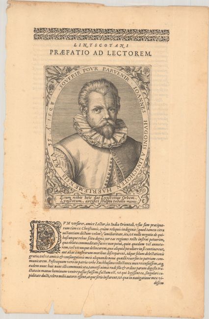
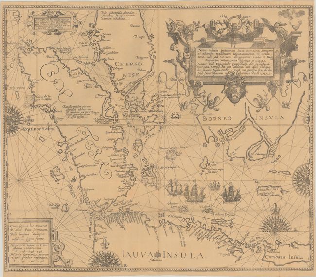
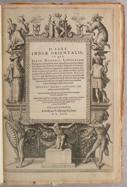
This is the first Latin edition of Part II of de Bry's Petits Voyages, chronicling Jan Huygen van Linschoten's voyages to Africa, India, and the East Indies from 1583-92. Included are 1 map, 39 plates, a portrait of Linschoten, title page, preface, 98 pages of text (out of 114 pages), and an index. Two of the three original maps (Goa and East Indies) from this volume are missing, although the map of the East Indies, Nova Tabula Insularum Javae, Sumatrae, Borneonis et Aliarum Mallaccam, has been replaced with a facsimile example. Also missing are 2 pages of the 3-page dedication, and 16 pages of the 114-page text for the volume. This example has been compiled from several different copies of the Latin edition, as the size of the sheets is not consistent throughout, and a number of pages are not bound into the volume. Hardbound in modern quarter faux vellum over marbled paper-covered boards with gilt titling on spine.
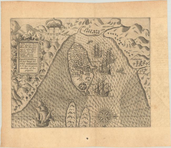
The map that is included is Insulae et arcis Mocambique descriptio ad fines Melinde sita ebano puriss… (12.4 x 9.6"), an attractive bird's-eye view of Melinde harbor in Mozambique that was engraved by Joannes a Doetecan. It shows the fortifications with numerous ships flying the Portuguese standard at anchor in the protected harbor. The map is finely engraved and decorated with a large compass rose, the Portuguese coat of arms, and title cartouche with the title in both Latin and Dutch.
All of the 39 plates issued in Part II are included. The following is a full list of the plates sorted by the region depicted and listing the plate number of each engraving:
Africa
1. The arrival of the Dutch at Gabam (Gold Coast)
2. What the Dutch experienced in a village called Cermentyn (Gabon)
3. Portrait of Ethiopians in Mozambique, called Caffres (Mozambique)
4. How the Bantu prove their success at war (South Africa)
Middle East
5. About the Arabs and those from the kingdom of Prester John
6. How the inhavitants of the island of Hormuz live
7. Persian merchants who travel from Aleppo to Hormus
India
8. An account of the Brahman and their merchants
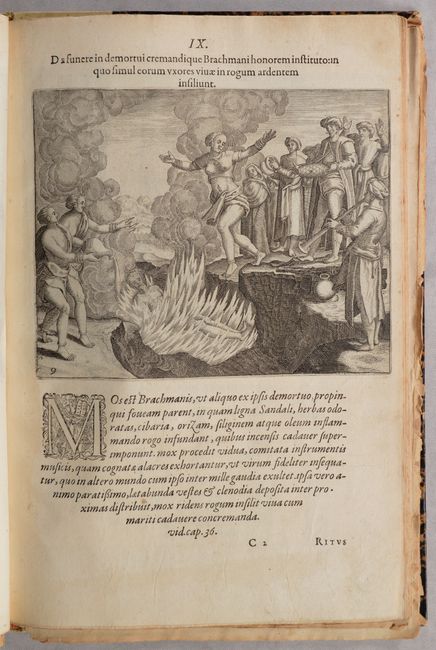
9. How the deceased Brahma are cremated
10. A wedding ceremony of the people near Goa
11. How the inhabitants of Balate swear an oath
12. King Hidalram's envoy in Goa
13. A portrait of an Indian actress
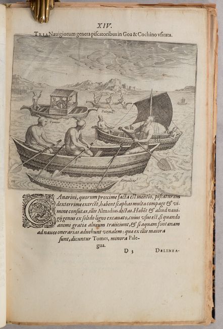
14. The kinds of boats used for fishing
15. The people of Malabar
16. Washing among the villagers
17. Merchant ships in India
18. The king of Cochin riding an elephant
19. A portrait of the Penekays from St. Thomas
21. The Indian idol pagodas and Moslem temples
22. Procession with the idol pagodas in the Indian kingdom of Narsinga
33. The aristocratic Portuguese in India
34. The Portuguese in India are carried in sedan chairs
35. How the Portuguese wives and daughters are transported
36. The pilgrimage of the Portuguese in India
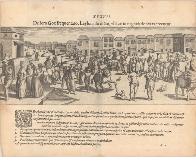
37. A panorama view of the market at Goa
38. How the Portuguese common-folk walk out
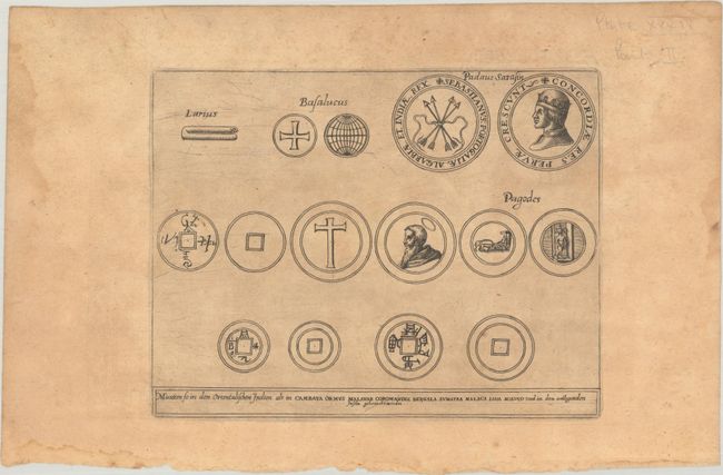
39. Coins and other artifacts used for trading in India
East Indies
20. People from Molucca and Java
China
23. The appearance of the Chinese folk
24. Transport for the aristocratic Chinese
25. Transport for the women of China
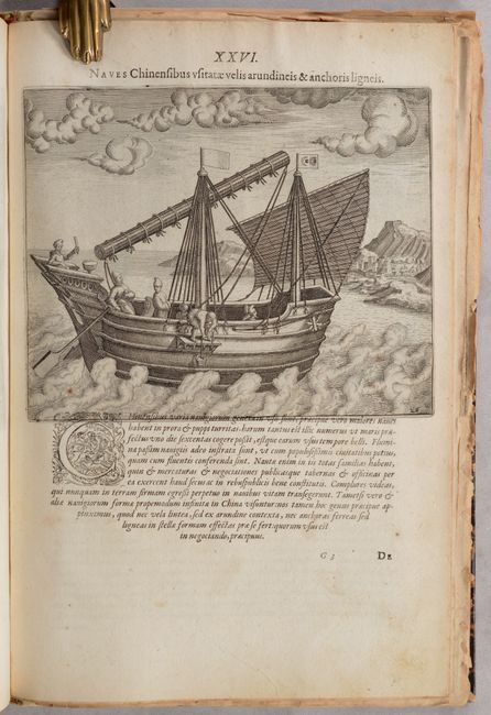
26. A typical Chinese ship
27. How certain Chinese become aristocrats
28. A strange ceremony of the Chinese
29. How the high ranking judges ride through the streets
30. A Chinese prison and place for execution
31. How the Chinese serve their guests and comfort the dying
32. How the Chinese bury their dead
References:
Condition: B+
The condition grade is for the map and plates. The map of Melinde Harbor is a dark impression on a watermarked sheet with minor toning, offsetting in the right blank margin, and a small paper flaw in the bottom margin. Nearly all of the plates are on bright sheets with minor soiling and occasional foxing; several of the plates have tiny tears along the fore-edge, some of which have been archivally repaired. Plate XXVII was trimmed by the bookbinder with loss of about 1/4" of the image at each side. The plate of coins is unnumbered, as issued, and is moderately toned with dampstains confined to the blank margins. The facsimile map of the East Indies is lightly toned with one tiny separation at the fold intersection. The portrait of Linschoten has some foxing and a 3" tear in the text at bottom that has been closed on verso with archival tape. The title page has very light soiling and a short tear in the bottom margin that has been archivally repaired. The text is mostly clean and bright, however a few pages are toned or soiled. The covers have a few small abrasions and the spine is soiled and age toned. A number of pages in the volume are detached.