Subject: Western North America
Period: 1846 (circa)
Publication: Travels Over the Table Lands and Cordilleras of Mexico
Color: Black & White
Size:
17.4 x 17.9 inches
44.2 x 45.5 cm
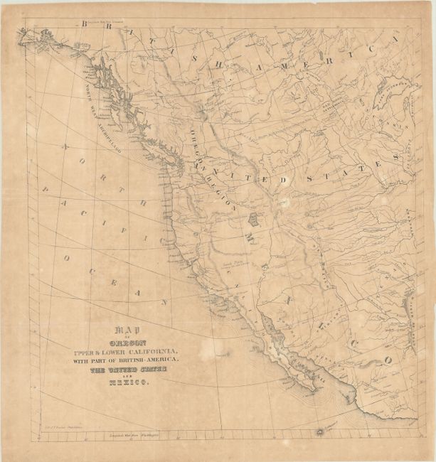
The United States and Great Britain established in 1818 joint claim over the Oregon Territory - the region north of Spanish controlled Upper California up to the southern boundary of Russia's Alaska Territory at North latitude 54°40'. By the late 1830's this arrangement was beginning to fall apart.
In the 1840's the expansionist Democrats, including their 1844 presidential candidate, James Polk, claimed the entire region for the United States. Their expansionist desires were expressed by Polk's famous campaign slogan, "Fifty-four Forty or Fight!" The slogan also became a rally cry for Americans desiring to settle the territory. Following Polk's election, the dispute was resolved by the 1846 Treaty of Oregon, which struck a compromise that fixed the U.S./Canadian boundary at 49º North.
This unusual and uncommon map was issued in Albert Gilliam's Travels Over the Table Lands and Cordilleras of Mexico and is primarily of interest for its geographical misconceptions of the western interior. It spans from Ft. St. Nicholas, the first European settlement on mainland Alaska, south to Acapulco, and extends as far east as Lake Michigan. The map was published the same year that the Oregon Treaty put an end to the contentious Oregon boundary dispute, but it shows the vast Oregon Region spreading into present-day British Columbia. The Republic of Texas is shown, with Austin, S. Antonio de Bexar, and Laredo named. The boundary between the United States and Mexico is indicated by a dotted line north of the Utah Salt Lake, and the Great Basin is noted as Sandy Plains Containing Salt Lakes & Swamps. Wheat notes that some of the geography reflects Fremont's 1843 map of the region, but that Gilliam clearly had not seen Fremont's map of 1845. Pikes Peak is called James Peak, the course of the Sacramento River (here named Saergeacuto R. for some reason) is incorrect, and the San Bruno Mountains, a range of hills to the south of San Francisco, are prominently noted while the Sierra Nevada are not identified. Lithographed by Thomas Sinclair in Philadelphia.
References: Howes #G-179; Sabin #27412; Wagner-Camp #120C; Wheat (TMW) #511.
Condition: B
Issued folding on a moderately toned sheet with several light spots, a dampstain in the right blank margin. and a few short edge tears, one of which has been closed on verso with cello tape. Remnants of hinge tape on verso.