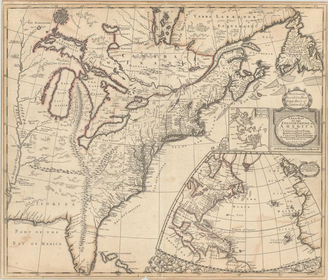
Subject: Colonial Eastern United States & Canada
Period: 1719 (dated)
Publication:
Color: Hand Color
Size:
23.3 x 19.8 inches
59.2 x 50.3 cm
This is a very important and scarce map of the eastern part of North America with interesting geographical misconceptions. One of the most prominent features is the trident-shaped mountain range extending from Michigan to Florida. In the area of the Carolinas, the mountain range extends west nearly to the Mississippi River, and northeast into the Appalachian mountains.
The map closely follows Richard Daniel's map of 1679, A Map of Ye English Empire in Ye Continent of America, which was later republished by Robert Morden with his own imprint circa 1685. Following the outbreak of King Williams's War (1689-97), there was renewed interest in the English Empire in America, and it is likely that Morden created this map to satiate British hunger for new information.
Numerous Jesuit and French sources (including maps by Dablon and Thevenot) served as the basis for information on the Great Lakes, Canada, and the Mississippi Valley. A number of exaggerated islands fill James Bay and the lakes Superior, Huron, and Nipigon. In the Southeast the features of John Lederer's 1672 map (A Map of the Whole Territory Traversed by John Lederer) are seen, including Ashley Lake, the Large Savana, and the Desert Arenosa. The boundary lines of the colonies are also quite interesting. Pennsylvania extends northwest beyond Lake Erie, and New York is not separated from New Jersey. The boundaries of the southern colonies are either omitted or haphazardly drawn.
Off the eastern seaboard is a large inset map of the North Atlantic showing the eastern part of North America and the West Indies, as well as the coastlines of Europe and Africa. Adjacent to the title cartouche is a small inset of Boston and vicinity, based on Thomas Pound's A New Mapp of New England from Cape Codd to Cape Sables (1691). This is the most recent information incorporated into the map.
This is the fourth state according to Burden and the fifth state according to Kershaw, with the imprint of John Senex and the coat of arms above the title replaced by a dedication to Herver Edgly Herver of Clapham. Engraved by John Harris.
References: Burden #750; Cumming (SE) #172; Kershaw #326; McCorkle #719.7; cf. Pritchard & Taliaferro #68; Stevens & Tree (MCC-39) #20b.
Condition: B+
A crisp impression with contemporary outline color on a sheet with a fleur-de-lis watermark. There is light color offsetting, minor foxing, a pencil notation in the title, and a small chip in the border at bottom. A 2" centerfold separation at top and a small chip in the border at bottom left have been closed with archival tape on verso.