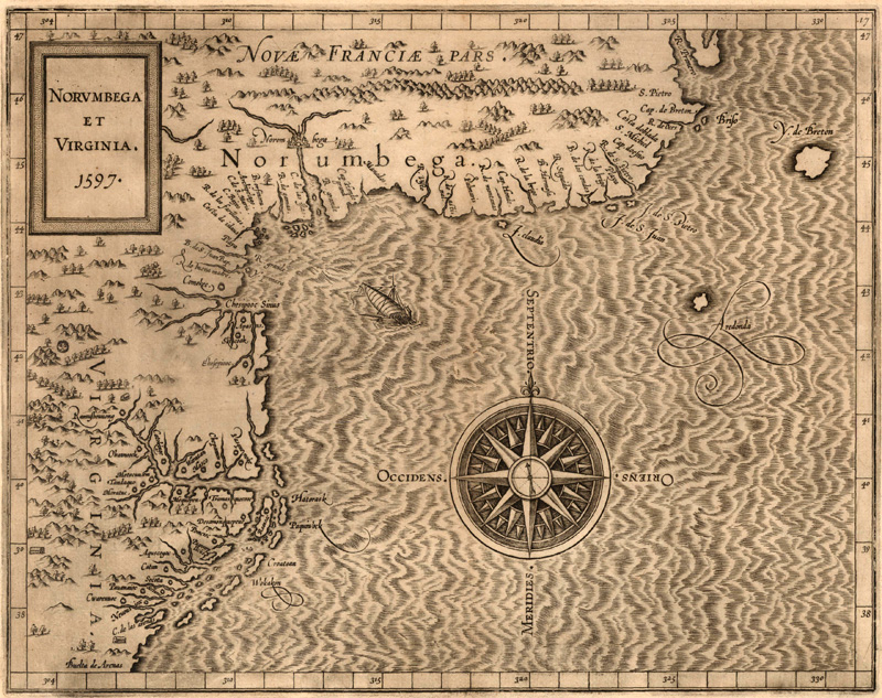
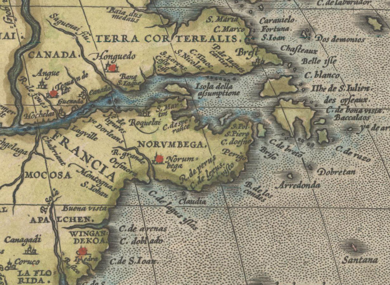
Norumbega et Virginia (1597) by Cornelis Wytfliet (Image courtesy of Old World Auctions)
Norumbega: The Dream Behind New England
by Joe McAlhany
Before there was New England, there was Norumbega. In the mid-to-late 16th century, Norumbega represented the promise of civilization and plenitude in the New World. When it first started appearing on printed maps in the 1540s, Norumbega sometimes referred to a river, a city, a region, an island, or some combination of the above. The place name was generally tied to the area around present-day Penobscot Bay in south central Maine, although its parameters were never defined with any consistency, with its extent reaching anywhere from New York to New Brunswick. In order to understand the myth that generated interest in the region, it is necessary to trace the origins of Norumbega as a name, a geographical location, and a concept. Assembled piecemeal over decades from several disparate accounts, most of them secondhand or anecdotal, the European idea of Norumbega was a fantasy land of great riches and resources, populated by gentle Indigenous peoples with a culture comparable to the great ancient societies. But instead of a northeastern El Dorado, the English and French explorers that traveled to Norumbega in the early 17th century found the wilds of Maine rather than promised riches.
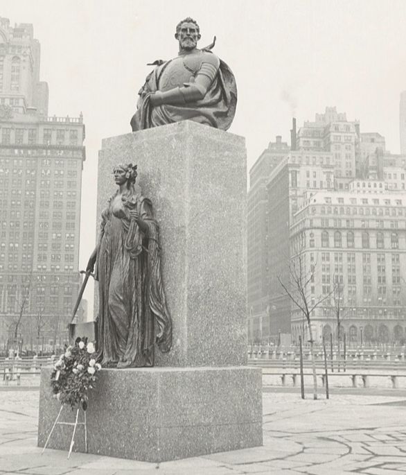
Any account of Norumbega must begin with Giovanni da Verrazzano. Verrazzano was a Florentine nobleman and explorer who settled in the French port city of Dieppe in 1506. At the behest of the merchants and moneymen involved in the silk trade, Francis I, King of France, commissioned Verrazzano to sail across the Atlantic and search the coast between Florida and Newfoundland for a possible passage to the Pacific. (To read about his findings on that front, refer to our March 2015 article on the myth of the Sea of Verrazzano.) In the early 16th century, the Europeans were somewhat familiar with the offshore fishing banks north of Cape Breton and with the vicinity of Cuba and Florida, but the vast stretch between these regions was still a mystery. On January 17, 1524, Verrazzano set out from the Portuguese island of Porto Santo across the Atlantic to demystify the eastern coast of the New World.
Angelo Rizzuto’s 1954 photograph of the Verrazzano monument in Battery Park (Image courtesy of the Library of Congress)
Verrazzano’s journey was documented in his July 1524 letter to Francis I, now referred to as the Céllere Codex. In this 12-page annotated manuscript, Verrazzano chronicles his adventure along the coast from Selva di Lauri (Cape Fear, North Carolina) to Cape Breton. He names and describes lush and promising landscapes in his voyage up the coast, among them Arcadia (somewhere in the vicinity of Maryland), Angoulême (New York Harbor), and, the most inviting of all, Refugio (Narragansett Bay, Rhode Island). Nearly a quarter of Verrazzano’s letter is devoted to his 15-day stay in this alleged paradise. According to Verrazzano, the natives of Refugio were statuesque, hospitable, and highly civilized, comparable in their demeanor to the “ancients.” Their architecture and agricultural infrastructure were surprisingly advanced, and he believed that the land could be cultivated to grow a rich variety of crops. He writes of the harbor (as translated by Susan Tarrow in Lawrence C. Wroth’s The Voyages of Giovanni da Verrazzano):
The harbor mouth [which we called “Refugio” on account of its beauty] faces south, and is half a league wide; from its entrance it extends for XII leagues in a northeasterly direction, and then widens out to form a large bay of about XX leagues in circumference. In this bay there are five small islands, very fertile and beautiful, full of tall spreading trees, and any large fleet could ride safely among them without fear of tempest or other dangers. Then, going southward to the entrance of the harbor, there are very pleasant hills on either side, with many streams of clear water flowing from the high land into the sea. In the middle of this estuary there is a rock of “viva pietra” formed by nature, which is suitable for building any kind of machine or bulwark for the defense of the harbor.
With its peaceful indigenous population, abundant land, and defensible harbor, Verrazzano saw in Refugio the possibility for a new European settlement. Upon departing Refugio, he continued another 150 leagues along the coast and observed a harsher terrain with hostile natives (likely the Wabanaki people of the Maine coast). By the time Verrazzano’s expedition neared Cape Breton, a region already explored by English, their supplies were largely depleted. It was time to head back to France and share their findings on the 700 leagues of new coastline they had just explored.
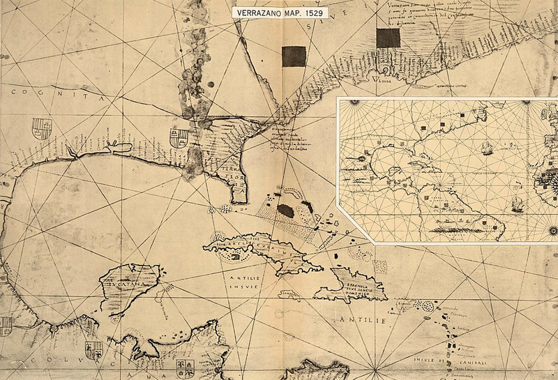
Even though it is never named in any form in the Céllere Codex, the seeds of the Norumbega myth are in Verrazzano’s idealized report of Refugio. But before we discuss how the characteristics of Edenic Refugio came to be associated with Norumbega, it is necessary to establish the convoluted origins of the name “Norumbega.” In the years immediately following Verrazzano’s return, his cartographer brother, Girolamo da Verrazzano, prepared a few manuscript maps documenting the voyage. The most important of these was the world map presented to Pope Clement VII in 1529. On this map, a small inlet labeled Oranbega is noted well to the north of Refugio and south of Terre onde he Male Gente (“the land where there are bad men,” referring to the rough patch of Maine coastline where Giovanni encountered the Wabanaki). The exact origins of the word “Oranbega” are an enigma, as Giovanni certainly never uses the name in his letter to the king. The scholar Kirsten A. Seaver makes an interesting case that the place name could be read as oro non bega (“no quarrel about gold”) or ora non bega (“no present quarrel”), attempts by the cartographer to cool potential conflict in the region over gold and other resources. Whatever its origin, it is generally accepted that Oranbega morphed into Norumbega.
A facsimile of the 1529 Girolamo da Verrazzano map (Image courtesy of the David Rumsey Map Collection)
One theory is that “Oranbega” blended with the Norman villa located between Angoulême and Refugio on Genoese cartographer Visconte Maggiolo’s world map of 1527 to form “Norumbega.” Edward Brooke-Hitching suggests as much in his entry on Norumbega in The Phantom Atlas. Another theory is that the “N” was added to Oranbega by mistake and propagated in a game of cartographic telephone. A third theory attributes the place name “Norumbega” to the native inhabitants of the region. The basis for this idea emerged from the anonymously authored Discorso d’un Gran Capitano di Mare Francese del Luogo di Dieppa (“Discourse of a Great French Sea Captain of Dieppe”), written in 1539 but not published until it was included in Giovanni Battista Ramusio’s Terzo Volume delle Navigationi et Viaggi in 1556. The work paraphrases Verrazzano’s description of Refugio and then states that the natives call the region Norumbega. Possible translations from the Wabanaki language include “where the river is wide” and “where there is quiet water between rapids,” but there is no reliable documentary evidence that this was an actual place name used by the Wabanaki. It could have been a casual description of the area, or a phrase borrowed from an Indigenous language and applied to the region after the fact.
Whether it was a genuine Indigenous moniker, a mistake, or an invention, Europeans would have been primed to accept the name “Norumbega” due to its echoing of “Nuremberg.” Renaissance thinkers embraced the concept of harmonia mundi, a Neoplatonic theory that suggested that there was a natural balance to all things. Part of this pseudoscientific belief was that the Old World and New World must mirror one another. Therefore, the idea that there was a New World city corresponding to Nuremberg, which was then a wealthy and culturally important midpoint between Italy and northern Europe, would have seemed logical to a contemporary European audience.
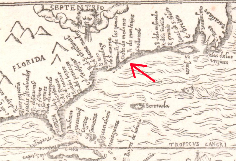
The next piece of the Norumbega puzzle is explaining how the place name came to define the area around what we now call Penobscot Bay. There is nothing in the Céllere Codex or Girolamo’s map to indicate that Verrazzano ever entered Penobscot Bay. Knowledge of the region instead came from an expedition developed in parallel to Verrazzano’s voyage. In early 1525, Estêvão Gomes, a Portuguese pilot sailing under the Spanish flag, departed for his own futile search for a passage to Asia. According to secondhand accounts, he traveled southwest along the coast from Nova Scotia to Cape Cod before turning back to Spain. Along the way, he journeyed up the Penobscot, which he dubbed El Rio de las Gamas, where he encountered Indigenous peoples with similar attributes to the residents of Verrazzano’s Refugio. On the highly influential map of the Gomes expedition, which was created by the Portuguese cartographer Diogo Ribeiro in 1529, Penobscot Bay is depicted as a large inlet filled with small islands, easily the most prominent geographical feature along the northeastern coast of the New World. The official Spanish charts derived from Ribeiro’s map, which were then secretly disseminated to the French and the Italians, further amplified the bay. Soon enough there was a widespread assumption that the bay of little islands and friendly natives described by Verrazzano was the same as the one described by Gomes.
R. de las Gamas, as discovered by Estêvão Gomes, on Jean Bellere’s Brevis, Exactaq. Totius Novi Orbis, et Peruviae Regionis Descriptio… (ca. 1566) (Image courtesy of Old World Auctions)
The connection was formalized by the narrative of Jean Alfonce de Saintogne, the navigator on Sieur de Roberval’s 1542-43 failed attempt to establish a colony along the St. Lawrence River. On the return voyage, Alfonce identified a Riviere de Norenbégue that was clearly the same river as Gomes’ Rio de las Gamas. He also wrote of a city 15 leagues up the river called Norombegue, which was populated by a noble tribe clearly modeled on the inhabitants of Verrazzano’s Refugio. It did not matter that Alfonce never actually traveled up the Penobscot - borrowing Verrazzano’s account lent legitimacy to his speculative city.
R. de Norebeque in Norumbega, from Carte de l'Amerique Corrigee et Augmentee… (1661) by Bertius/Tavernier (Image courtesy of Old World Auctions)
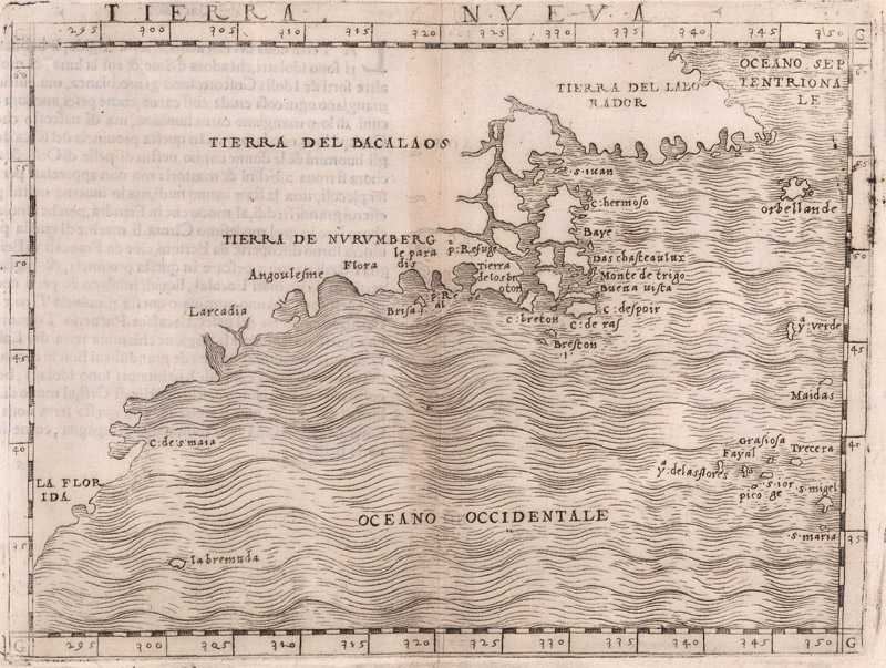
Variations of Norumbega began appearing on charts made by cartographers of the highly respected Dieppe school, like Pierre Desceliers, whose 1546 world chart features an inlet labeled A norobagra in present-day Maine. But it was the publication of Giacomo Gastaldi’s Tierra Nueva in 1548 that really put Norumbega on the map, so to speak. Published in Gastaldi’s edition of Ptolemy’s Geographia - the first edition to include maps of the New World - Tierra Nueva was the earliest printed map to focus on the eastern coastline of North America. It was also the first widely-distributed printed map to show Norumbega - and not just as an inlet, but as an entire region. On the map, Tierra de Nurumberg is a zone encapsulating Verrazzano’s discoveries, covering the coastal region from Angoulesme to Po: Refuge.
Tierra Nueva (1548) by Giacomo Gastaldi (Image courtesy of Old World Auctions)
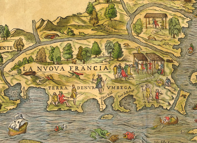
Another Gastaldi map, La Nuova Francia, published in 1556 by Ramusio in the aforementioned Terzo Volume delle Navigationi et Viaggi, further articulates the region. Terra de Nurumbega dominates the southern coast of La Nuova Francia, a large island spanning from New York to Cape Breton. Port du Refuge is once again depicted along Norumbega’s southern coast, this time speckled with islands. But the most striking element are the pictorial representations of Norumbega’s inhabitants that fill the landscape. In appearance they are somewhere between Old World and New World, hunting with bows and arrows and dancing under makeshift shelters, but dressed in tunics like the ancients. Ramusio’s volume contained the first published version of the Verrazzano letter (translated into Italian), the anonymous Discorso d’un Gran Capitano, and the map of New France, making it the most comprehensive compilation of material on Norumbega yet.
Terra du Nurumbega, from La Nuova Francia (1556) by Gastaldi/Ramusio (Image courtesy of Old World Auctions.)
If it was Gastaldi and Ramusio who spread the concept of Norumbega to a wider audience, it was Richard Hakluyt who sold the English on the mythical region. The English had largely ignored the New World after John Cabot’s discovery of Newfoundland in 1497. Hakluyt’s Divers Voyages, published in 1582, was an attempt to rally the English around the concept of colonizing Norumbega. It included an English translation of Ramusio’s Terzo Volume (and all its material on Norumbega) and a phony story in which Verrazzano presents Henry VIII with a map of his expedition along the coast of the New World, a none-too-subtle attempt to suggest that the English may have rights to Verrazzano’s findings. The volume also featured a map credited to Michael Lok, which showed the Northwest Passage via the Sea of Verrazzano and depicted Norumbega as an island not unlike Britain herself (another instance of the harmonia mundi concept). Lok’s cartography was sketchy at best, but it presented the English with an appealing vision of the possibilities of the New World.
The Michael Lok map (dated 1582) with an insular Norombega, as it appeared in Divers Voyages (Image courtesy of the Library of Congress.)
Hakluyt’s work was pivotal in garnering interest in Sir Humphrey Gilbert’s efforts to colonize Norumbega. In 1578, Queen Elizabeth granted Gilbert a 6-year license to explore the northeastern coast of North America. It was only after the publication of Divers Voyages that Gilbert was finally able to secure financial backing for his voyage. Inspired in part by the spurious account of David Ingram, an English adventurer who claimed to have walked from Mexico to Nova Scotia in 1568, Gilbert hoped to claim for the English crown 9 million acres around the Norumbega River. Ingram had supposedly seen the great city of Norumbega and spoke of its unbelievable riches. Unfortunately, Gilbert never made it to the golden city. Although his misfit crew did claim Newfoundland for the English in August 1583, they quickly ran out of supplies and had to return home. Gilbert did not survive the journey back to England.
By the end of the 16th century, both the French and English had their eyes fixed on Norumbega. The region was a common fixture on maps showing the New World, appearing in the atlases of the two most important cartographers of the era, Abraham Ortelius and Gerard Mercator. Ortelius’s world map of 1570 locates a city called Norobega, marked by a castle, the same symbol used to locate the great fortified cities of Europe. His map of the Americas, Americae sive Novi Orbis, Nova Descriptio, takes the depiction even further, situating the city of Norumbega on the banks of a river (R. Grande) in a wider Norumbega region south of the St. Lawrence. The Mercator family’s maps follow a similar pattern. Rumold Mercator’s 1587 world map shows a city of Norumbega, while Michael Mercator’s 1595 map of the Americas shows Norumbega as both territory and city.
Norumbega, from Americae sive Novi Orbis, Nova Descriptio (1570) by Abraham Ortelius (Image courtesy of Old World Auctions.)
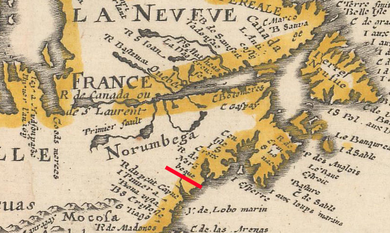
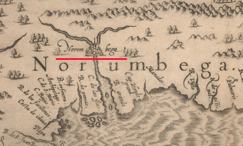
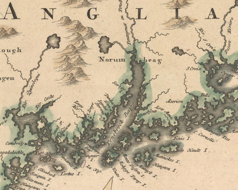
Norumbega was never more in the spotlight than on Cornelis Wytfliet’s Norumbega et Virginia (1597). As was typical of maps of the period, the eastern coast was strangely compressed so that the distance between Chesapeake Bay and New England had been elided. All that remains are the two great colonial prospects of the title, Norumbega and Virginia. Norumbega appears here at the river’s fork, identified by the symbol for a large city that suggests a completely fictitious level of architectural sophistication. Other Indigenous settlements are humbly noted down in Virginia, but the map presents Norumbega as the main attraction, the crown jewel of the New World.
Close-up of the grand city of Norumbega, from Norumbega et Virginia (1597) by Cornelis Wytfliet (Image courtesy of Old World Auctions.)
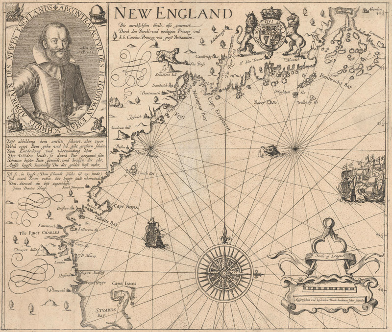
That vaunted image of Norumbega would be tempered by further exploration. In the first decade of the 17th century, the French and English had conducted comprehensive surveys of the region’s coast. As an accurate picture of the area started to come into focus, the Norumbega myth began to dissolve. The idea of a great city at the core of the region was put to rest by Samuel de Champlain, who ventured up the Penobscot River in 1604 and found that the mighty city of Norumbega was little more than a rudimentary Indigenous settlement. The land once called Norumbega would soon come to be known as New England with the publication of John Smith’s 1616 map of the region.
New England (German edition - ca. 1617) by John Smith (Image courtesy of Old World Auctions.)
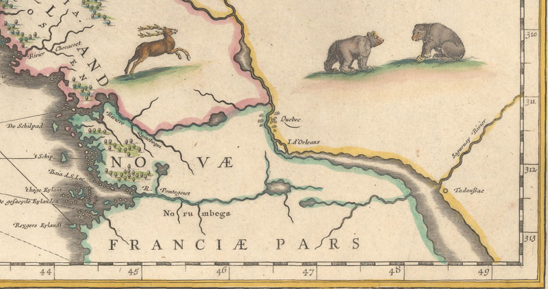
As with many cartographic myths, Norumbega had a long tail; it is difficult to let go of a dream. Great mapmakers such as Willem Blaeu and Jan Jansson included Norumbega on their maps of New England. On Blaeu’s map of 1635, it is the designation given to a stretch of territory along the Penobscot (R. Pemtegomet), while on Jansson’s 1636 map it names a mostly unmapped area of present-day Maine. Norumbega hangs on as a cartographic remnant into the 18th century, with a notable late example being Johann Baptist Homann’s Nova Anglia Septentrionali Americae Implantata Anglorumque Coloniis Florentissima (1724), where the name emblazons the head of Penobscot Bay (Penebrock Bay). But in all these later examples, Norumbega has been subsumed by the concept of Nova Anglia.
Norumbega along R. Pemtegomet, from Nova Belgica et Anglia Nova (1635) by Willem Blaeu (Image courtesy of Old World Auctions.)
Norumbeag around Penebrock Bay, from Nova Anglia Septentrionali Americae… (ca. 1724) by Johann Baptist Homann (Image courtesy of Old World Auctions.)
The Norumbega myth received a strange revival in the late 19th century, thanks to the eccentric Eben Norton Horsford, a chemist and former professor who in his later years developed an obsession with the idea of Vikings landing in New England. In a series of outlandish publications, Horsford made the case that Leif Erikson had arrived in Cambridge, Massachusetts in the year 1000 A.D. and that there was a Norse fort called Norumbega at the confluence of Stony Brook and the Charles River. As preposterous as his theories were, Horsford managed to drag the Norumbega myth out of the grave and down the coast from Maine to Massachusetts, rebranding it as Viking history and literally building a monument to commemorate the whole pseudohistorical enterprise. His Norumbega Tower, constructed in 1889 to mark the hypothetical location of Fort Norumbega, still stands today in Weston, Massachusetts.
There is something almost poignant about Horsford’s refusal to let the myth go. In that spirit, the Norumbega name still lives on. Aside from Horsford’s tower, there are several places in Maine that have taken the Norumbega name as a tribute to the region’s mythical past, among them Norumbega Mountain in Arcadia National Park, Norumbega Castle, a historic stone manse near Penobscot Bay that has been converted to a bed-and-breakfast, Norumbega Hall in Bangor, and a number of local businesses. None of these places can match the outsized hopes of the explorers who first sailed past the coast of New England, but the names are a reminder of the beliefs and illusions that drove colonists to the region in the first place, the legend behind the reality of New England.
REFERENCES
Adams, Cecil, “Did Leif Erikson Once Live in Cambridge, Massachusetts?,” The Straight Dope, April 30, 2002. https://www.straightdope.com/21343139/did-leif-erikson-once-live-in-cambridge-massachusetts
Brooke-Hitching, Edward, The Phantom Atlas – The Greatest Myths, Lies and Blunders on Maps, Chronicle Books LLC., San Francisco, 2018.
D’Abate, Richard, “On the Meaning of a Name: ‘Norumbega’ and the Representation of North America,” American Beginnings: Exploration, Culture, and Cartography in the Land of Norumbega, ed. Emerson W. Baker, Edwin A. Churchill, Richard D’Abate, Kristine L. Jones, Victor A. Konrad, and Harald E.L. Prins, University of Nebraska Press, 1994.
Quinn, David B., “The Early Cartography of Maine in the Setting of Early European Exploration of New England and the Maritimes,” American Beginnings: Exploration, Culture, and Cartography in the Land of Norumbega, ed. Emerson W. Baker, et al., University of Nebraska Press, 1994.
Seaver, Kirsten A., “Norumbega and ‘Harmonia Mundi’ in Sixteenth-Century Cartography,” Imago Mundi, Vol. 50, 1998. https://www.jstor.org/stable/1151390
Wroth, Lawrence C., The Voyages of Giovanni da Verrazzano 1524-1528, Yale University Press, 1970. https://archive.org/details/voyagesofgiovann0000wrot/page/n7/mode/2up