Subject: Northern United States & Canada
Period: 1870 (circa)
Publication:
Color: Hand Color
Size:
28.8 x 20.8 inches
73.2 x 52.8 cm
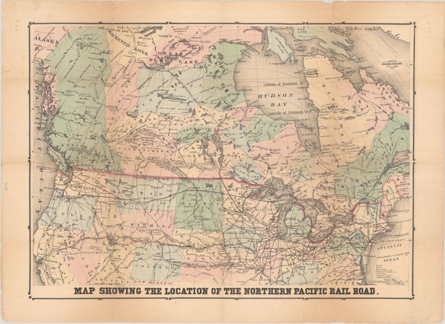
An attractive and information-packed map lithographed by M.H. Traubel in Philadelphia. It shows the proposed main line of the Northern Pacific Railroad (NPRR) extending from St. Paul/Duluth west to Portland and Seattle along with additional spoke lines all highlighted in red. Other railroads are shown with alternating black/white lines including the Central Pacific and Kansas Pacific railroads. Concentric circles radiate out from Duluth, showing distances in 100-mile increments. An unusual feature of this map is the use of isothermal lines to indicate summer temperatures in an attempt for the region to appear more temperate, with additional notations around the main line locating the "Latitude of Venice" and "Latitude of Paris." The map heavily emphasizes mineral resources including gold in California, Utah, Colorado, and Montana and silver in Nevada. Interestingly, there is no mention of any Native American presence (an obstacle to development), but many forts are noted. The map was clearly produced to promote investment along the railroad and the West more broadly. We found only one past sales record for this map in the last 40 years.
References: Phillips (Maps) p. 622.
Condition: B
Folded with some minor toning and foxing. Numerous fold separations throughout have been archival repaired on verso with minor image loss at a few fold junctions.