Subject: United States
Period: 1869 (dated)
Publication:
Color: Printed Color
Size:
41.3 x 28.3 inches
104.9 x 71.9 cm
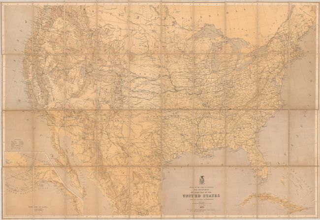
This detailed map of the United States was compiled and drawn by Edward Freyhold. It is a simplified and reduced version of his 1868 map, which itself was an update to Lieutenant Warren's general map of 1857. The map shows fine detail of the river systems and topography, and a legend at left further identifies towns and cities, railroads, canals, wagon and military roads, and forts. This edition does not delineate military districts in red overprinting as noted in Wheat (see Rumsey reference). The map extends to include good detail of much of Mexico and a portion of western Canada. The Union Pacific Railroad is shown as complete with a new station situated to the north of the Great Salt Lake. Includes an inset of Alaska at lower left. Note at bottom states "In the compilation of this map the Authorities designated on the map of the Western Territories (Freyhold's 1868 map) as well as others of more recent date have been used." Lithographed by Julius Bien in New York. Self-folding into marbled wrappers. We found no past sales records for this map in the last 30 years, and two only two institutional examples (Library of Congress and Boston Public Library).
References: cf. Rumsey #3849; cf. Rumsey #2919 (1868 map); cf. Wheat (TMW) #1204.
Condition: B
Dissected and backed with linen. There is some light toning and staining throughout.