Subject: United States
Period: 1892 (dated)
Publication:
Color: Printed Color
Size:
58 x 44 inches
147.3 x 111.8 cm
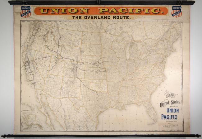
This scarce wall map was issued by the Union Pacific Railroad as an advertising map, likely distributed to travel agents and placed in rail stations. It shows the entire United States with the route of the Union Pacific Railroad depicted in bold black originating in Kansas City, Leavenworth, St. Joseph, Omaha, Council Bluffs, Sioux City and Fort Worth. The rail lines extend to the west coast and the Pacific Northwest with a sub-network in and around Denver. Across the top is a second banner-style title "Union Pacific / The Overland Route" in bold red and yellow with the company's logos at either side. The map is titled at lower right with fancy calligraphy typical of the period. This scarce edition was published by the Knight, Leonard company of Chicago. The more common 1896 edition, published by Rand, McNally in a slightly smaller format, bears an identical title which is printed at a slight tilt. This edition has insets of Alaska and the Sandwich Islands at lower left, not in the Rand McNally version.
References: Modelski #597.
Condition: B+
The map is bright with a number of archivally repaired edge tears along the top sheet edge that just enter the map border along with several longer repaired tears in the Gulf of Mexico at bottom. There is some minor soiling and foxing and a number of small repaired edge chips in the blank margins. Professionally mounted on linen with rollers.