Subject: United States
Period: 1945 (dated)
Publication:
Color: Printed Color
Size:
19.6 x 28.8 inches
49.8 x 73.2 cm
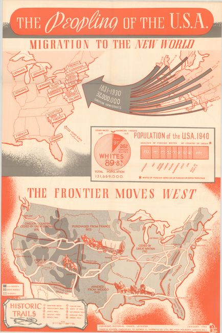
This educational piece features two maps on one sheet by Pictorial Charts in Leicester, England. The top map illustrates European immigration to the United States over a 100-year period (1831-1930). Various labels throughout the eastern United States identify large clusters of ethnic backgrounds including German, French, Italian, Irish, Scottish and more. A pie chart below the map indicates that nearly 90% of the 132 million U.S. inhabitants were white and 26% of those were of foreign birth. 0.3% are noted as Native American. The map at bottom presents the territorial acquisitions of the United States, including a typo that Oregon Country was ceded by Great Britain in 1876 (1846)! The map is color-coded to show elevation and includes a key with 10 important trails to western migration. The map was used as a teaching tool by British educators with note at bottom "Trade & School Enquiries to George G. Harrap & Co. Ltd." We found only one past sales record for this map in the last 30 years and no institutional examples on OCLC.
References:
Condition: A
Issued folding on a clean sheet.