Subject: Eastern United States
Period: 1799 (circa)
Publication: Voyage au Canada...
Color: Black & White
Size:
18.6 x 16.2 inches
47.2 x 41.1 cm
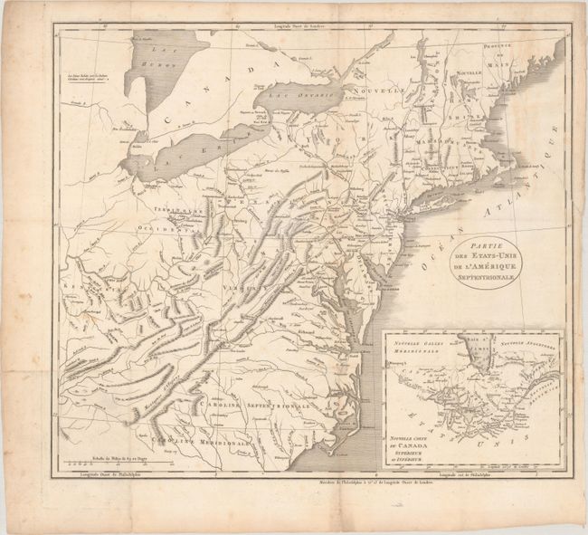
This map appeared in a French edition of Weld's Travels Through the States of North America and is essentially John Stockdale's map from the year prior with a different inset. It is filled with great information on early development including roads and settlements. The map covers from the Province of Main through South Carolina and beyond the Appalachian Mountains to Western Territory and Kentucky. Weld's route is delineated from Lake Ontario to the Chesapeake Bay. Villages of "Christian Indians" are located by small icons. This edition of the map has an inset of Canada centered on the Great Lakes instead of the Carolinas.
A member of the Irish gentry, Isaac Weld traveled to North America as a young man in search of adventure. He visited the settled regions of the eastern seaboard and then ventured into the hinterland with the assistance of Indian guides. Weld's account of his travels is one of the earliest illustrated amateur travel accounts to be devoted to North America. It was very popular and went through several editions in English with translations into French, German, Italian, and Dutch.
References: McCorkle #799.6.
Condition: B
Issued folding with light foxing, minor staining, and a 6.5" edge tear at top right that has been archivally repaired on verso. Several short fold separations are confined to the wide blank margins.