Subject: World
Period: 1730 (circa)
Publication:
Color: Hand Color
Size:
38.3 x 22.3 inches
97.3 x 56.6 cm
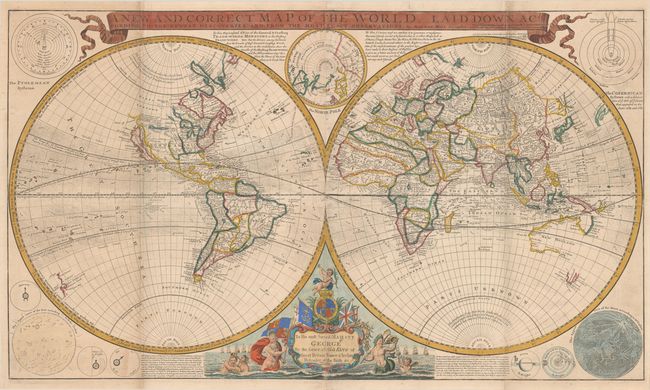
This very large, impressive world map is one of the first to record prevailing wind directions based on scientific observation. It was designed for a British public interested in maritime exploration and commerce and thus to encourage subscriptions for Moll's New and Complete Atlas. In North America, California is shown as an island, a prominent River of the West is "laid down according to the Baron Lahontan's discoverie [sic]," and most of the Arctic is labeled "Parts Unknown." In northeastern Asia, Iesso Land (Hokkaido) is shown to be part of Siberia with Companys Land lying just offshore. Only the western and northern coasts, and a bit of Diemens Land, are shown in Australia. Surrounding the hemispheres are a variety of astronomical diagrams, including representations of the planets, the moon, a north polar projection, and the solar systems theories of Ptolemy and Copernicus. The title is enclosed in a banner-style cartouche at top. This is the second state with a large dedication cartouche to George II. Of particular interest is the vitriolic attack on Moll's competitors, particularly French cartographer Nicolas Sanson ("whose maps have been condemned and found to be notoriously false"). Moll goes on to claim the Dutch maps are inaccurate and often illegal piracies. With the imprints of J. Bowles, T. Bowles, and P. Overton. Printed on two sheets, joined as issued.
Herman Moll was one of Britain's most prominent cartographers of the first half of the 18th century. He emigrated from Germany and went to work as an engraver for Moses Pitt in 1678. Soon he joined one of London's most interesting social circles, which gathered at Jonathan's Coffee House, and included stock speculators, scientists, archaeologists, authors, pirates, and sea-captains. From these friends, Moll gained a great deal of privileged information that he compiled into his cartographic works. Moll's success and prosperity was due in part to his social connections and political astuteness, and to his distinctive style and quality workmanship. He produced a great number of often-innovative maps, charts, globes, atlases and geographies. His best known works are the large maps produced for his World Described (and also published separately) including this world map and the famous Beaver and Codfish maps of North America.
References: cf. Shirley (BL Atlases) T.MOLL-4c #1.
Condition: B+
A nice impression with contemporary outline color in the map and later color in the decorative elements. There are a few tiny wormtracks along the equator at center, minor soiling along the upper vertical folds, and a small horizontal printer's crease at right. A short fold separation at bottom right has been closed with tape on verso.