Subject: Colonial Mid-Atlantic & Southeastern United States
Period: 1780 (circa)
Publication: Atlante Novissimo
Color: Hand Color
Size:
16.8 x 12.6 inches
42.7 x 32 cm
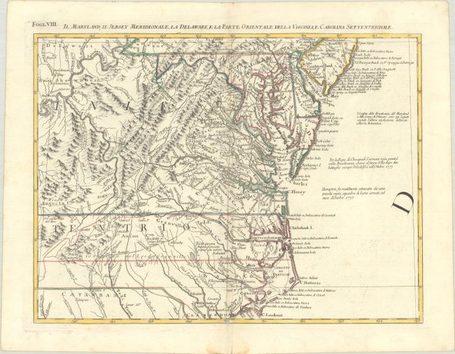
This great regional map was sheet VIII of Zatta's Italian edition of Mitchell's seminal map of the British Dominions in North America. The map extends from Philadelphia and the Delaware Bay south to Cape Lookout and the Welsh Settlement in Carolina. To the west are the Allegheny Mountains and a large portion of the Ohio River. The map has remarkable detail of towns, villages, roads and trails, and watershed topography. Based on the earliest available English and indigenous surveys, Zatta issued the large map in 12 sections with the whole titled Le Colonie Unite dell' America Settentrle. Zatta's maps retain Mitchell's scale, but being smaller are more legible. An example of this map was used as late as 1932 in a boundary dispute between Delaware and New Jersey. Each sheet stands on its own and has full borders.
References: Portinaro & Knirsch #151; Shirley (BL Atlases) T.ZAT-1a, Vol. 4, #35
Condition: A
A crisp impression with contemporary outline color on a sheet with the watermark of three crescent moons. There is a faint dampstain that barely enters map image near centerfold at bottom and minor offsetting.