Subject: Colonial Southern United States
Period: 1737 (dated)
Publication: Recueil de Voiages au Nord...Tome Neuvieme
Color: Black & White
Size:
10.3 x 7.5 inches
26.2 x 19.1 cm
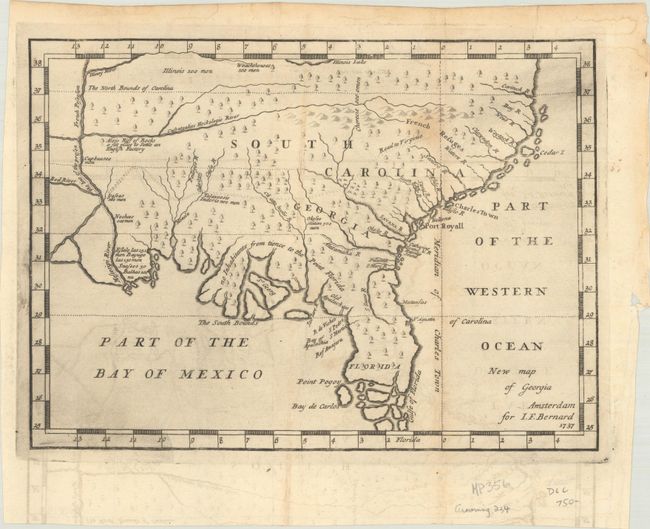
This scarce map is one of the earliest published maps of the English colony of Georgia. It is a larger example that was apparently taken from the 1733 map in Benjamin Martyn's Reasons for Establishing The Colony of Georgia, although with numerous errors and omissions. The original map has also been attributed to James Oglethorpe, founder of the British Georgia colony in 1732, and presents extensive English claims southward to just north of St. Augustine, no doubt inflaming Spanish interests at the time. This hostility led to the War of Jenkins Ear in 1739. The map covers the region from Florida and up the east coast extending north to above the Cartuck River at the northern border of South Carolina. It extends west to beyond the Mississippi River, showing all of colonial South Carolina, Georgia and Florida. The southern portion of Florida is composed of numerous islands. A southerly bloated coast along the Florida panhandle suggests vast lands that could be utilized by farmers under the “Oglethorpe Plan” for colonization. Coincidentally, the lands end at the line demarcating “The South Bounds of Carolina.” Few settlements are identified, with the exception of Charles Town, Port Royall, St. Augustine and a few others, and the prime meridian is drawn at Charleston. This map also includes notations related to the number of men in various Indian tribes: Illinois 500 men, Weachthenoes 500 men, Okesee Nation 700 men. A fascinating map that was clearly constructed to promote the Georgia colonization efforts.
References: Cumming (SE) #234; Sabin #4936.
Condition: B+
A dark impression, issued folding on a sheet with the Amsterdam coat of arms watermark, now flattened with some offsetting and printer's ink residue. There is a faint stain north of Charleston and minor toning along several folds and the edges of the sheet.