Subject: Arizona, United States
Period: 1948 (circa)
Publication:
Color: Printed Color
Size:
10.5 x 8.3 inches
26.7 x 21.1 cm
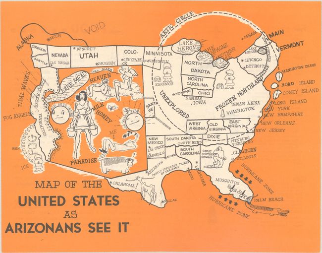
This humorous map of the United States is drawn from the perspective of an Arizonan. The map presents an over-sized Arizona encompassing nearly the entire western half of the United States. The state is noted as a land of milk and honey, heaven, and paradise with accompanying imagery. The map was published in a tourist brochure to attract visitors to Arizona, and the map ensures that all other states seem inhospitable in comparison to Arizona. The entire Midwest and Northeast is within an Arctic Circle, with the region identified as "frozen Northland" and "unexplored." States that typically compete with Arizona as havens for sun-seekers are redefined by their least desirable traits: California is plagued with earthquakes, tidal waves, and fog; Florida is filled with mosquitos, alligators and a swamp; and Texas is reduced to a state of "partly civilized tribes of Texans." Remaining states are either misplaced or outright missing. A fun and playful map for Arizonans. There is additional tongue-in-cheek text on verso. This map was the centerfold of a tourist brochure on Arizona, that was illustrated by Leigh St. John and published by Oren Arnold.
References:
Condition: A+
Crisp and clean with small staple holes along the centerfold, as issued.