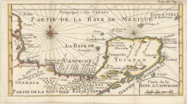
Subject: Southeastern Mexico
Period: 1715 (circa)
Publication: Nouveau Voyage Autour du Monde...
Color: Hand Color
Size:
10.8 x 5.8 inches
27.4 x 14.7 cm
William Dampier (baptized 1651-1715) was a buccaneer (pirate) and sea captain. He was the first Englishman to explore parts of New Holland and New Guinea, and was the first man to circumnavigate the world three times.
In the 1670s he crewed with buccaneers on the Spanish Main of Central America, which eventually led to his first circumnavigation. On the ship Cygnet, following Pacific-spanning raids that included the East Indies, Manila, and the Spice Islands, Dampier's ship was beached on the northwest coast of Australia in 1688. Waiting for repairs, his scientific interest surfaced as he made notes and drawings on the local fauna and flora. Following three years of further adventures he returned to England. In 1697 he published his experiences in A New Voyage. Described as one of the greatest tales of adventure and exploration ever written, the book was published in several languages. It is reported that Captain Cook used Dampier's nautical observations on his voyages, and Charles Darwin found his books so useful that he took them aboard the Beagle.
This is the French edition of the scarce map of the Bay of Campeche and the Yucatan Peninsula that Herman Moll engraved for the chronicle of Dampier's voyages. It covers the region first explored in 1517 by Fernando de Cordoba and Antonio de Alaminos and visited by Dampier twice prior to his circumnavigations. Detail is limited primarily to coastal place names, several rivers, and mountains in profile. The city of Campeche derives its name from the Mayan chiefdom of Can Pech. The Sacrificios (Island of Sacrifices), located just offshore from Veracruz, is the location of a prominent Aztec temple discovered by the Spanish in 1518. There are no place names along the coastline now known as Riviera Maya, but Cozumel Island is named and the city of Valladolid is located. Decorated by a compass rose capped by a fleur-de-lis and rhumb lines.
References:
Condition: B+
A nice impression issued folding, now flat, with light toning along the left fold, a few minor spots, and a tiny archivally infilled wormhole that just touches the neatline at top right.


