Subject: World
Period: 1643 (circa)
Publication:
Color: Hand Color
Size:
7.6 x 5.8 inches
19.3 x 14.7 cm
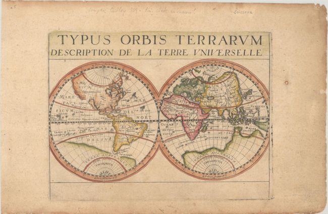
This uncommon double-hemisphere world map is attributed to Jean Boisseau and appeared in several different publications. Although Rodney Shirley's cartobibligraphy of the world only notes an example of this map with plate number "3" engraved at bottom right, this unnumbered example appears to be from the same plate. It is unknown which state came first, however there are no signs of erasures on this unnumbered example so it is possible that this example is the first state. Geographically the map is similar to Henricus Hondius' map of 1630. In North America it presents California as an island, a stretch of land to the northwest of California with the place names Nova Albion and Serra Nevado, and no Great Lakes. The Dutch discoveries on the Carpentaria coast of Australia are shown, which is connected to the great Terra Australis Incognita stretching across both hemispheres. Tierra del Fuego and Le Maire Strait are shown at the tip of South America.
References: Shirley #359.
Condition: B+
A crisp impression on a lightly toned sheet with minor soiling and a repaired hole in the right margin. There are some pencil notations in the blank margins.