Subject: Bermuda
Period: 1930 (dated)
Publication:
Color: Printed Color
Size:
34.3 x 24.3 inches
87.1 x 61.7 cm
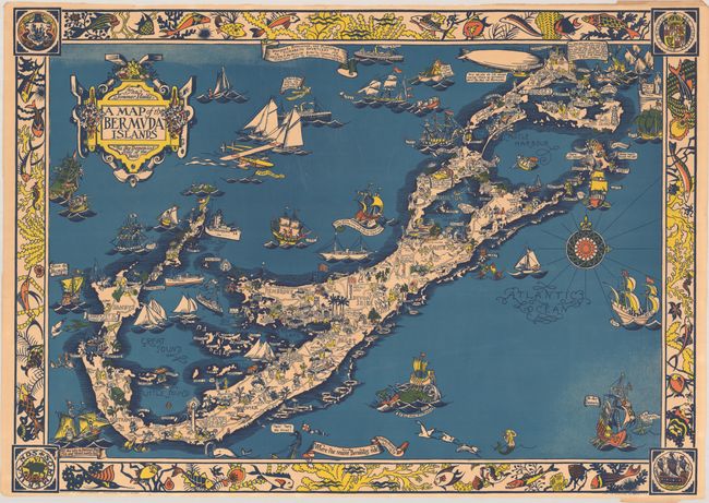
This stunning pictorial map of Bermuda was "designed, executed, and published" by Elizabeth Shurtleff and Helen F. McMillin. The archipelago is dense with charming illustrations highlighting history, culture, architecture, and recreation. In a nod to the islands's cartographic history, British surveyor Richard Norwood is pictured toiling over a map, dividing the islands into 8 tribes in 1618. The surrounding waters are filled with vessels from different eras of history: there is the island's namesake Juan de Bermudez returning to the island in 1515; a rowboat with the 1615 charter for the Somer Islands [sic]; a rendering of the infamous Gunpowder Plot of 1775; and the Prince of Wales's visit in 1920. The design of the strapwork title cartouche and compass rose recall antique maps. Surrounding the map is a vibrant border of fish and sea flora designed by Elizabeth L. McMillin, Helen's niece. On verso is information on each parish, a list of hotels and books on Bermuda, and a quote from Mark Twain (who is also evoked in the map). Published by the Graphic History Association, the pictorial map publishing concern established by Shurtleff and McMillin. Distributed by Bermuda Bookstores. Lithography by the Tudor Press.
Elizabeth Shurtleff (1890 - 1968) was a painter and artist born in Concord, New Hampshire and educated at Boston Museum School of Fine Arts. Helen F. McMillin (1896 - 1987) was an editor, publisher, and illustrator from North Adams, Massachusetts, who studied at Wellesley College and published Granite Monthly and worked for the Museum of Modern Art. From 1926 to 1930, the two women designed a group of pioneering pictorial maps, published by their own company, the Graphic History Association. They were key figures in the cluster of women mapmakers who shaped the aesthetics and conventions of pictorial cartography in the early 20th century.
References: Hornsby (Picturing America) pp. 22-23; Rumsey #7862.002.
Condition: B+
A vibrant example with a faint dampstain in the top border and a 0.5" edge tear in the bottom border that has been closed on verso with archival tape. The edges have been trimmed and are slightly chipped mostly at top and bottom, but there is still ample margin for framing.